You are here: Home > Network List > US - United States National Seismic Network Stations List
> Station AMTX Amarillo, Texas, USA > Earthquake Result Viewer
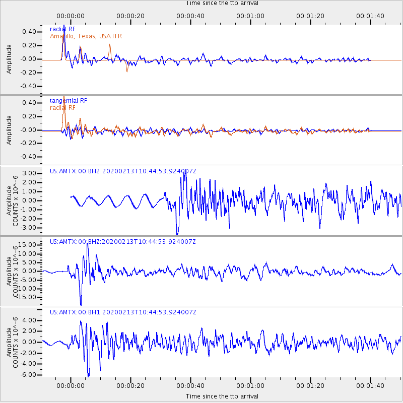
AMTX Amarillo, Texas, USA - Earthquake Result Viewer
*The percent match for this event was below the threshold and hence no stack was calculated.
| Earthquake location: |
Kuril Islands |
| Earthquake latitude/longitude: |
45.6/148.9 |
| Earthquake time(UTC): |
2020/02/13 (044) 10:33:44 GMT |
| Earthquake Depth: |
144 km |
| Earthquake Magnitude: |
7.0 mww |
| Earthquake Catalog/Contributor: |
NEIC PDE/us |
|
| Network: |
US United States National Seismic Network |
| Station: |
AMTX Amarillo, Texas, USA |
| Lat/Lon: |
34.53 N/101.41 W |
| Elevation: |
1010 m |
|
| Distance: |
78.0 deg |
| Az: |
52.626 deg |
| Baz: |
317.515 deg |
| Ray Param: |
$rayparam |
*The percent match for this event was below the threshold and hence was not used in the summary stack. |
|
| Radial Match: |
90.104996 % |
| Radial Bump: |
324 |
| Transverse Match: |
73.54083 % |
| Transverse Bump: |
400 |
| SOD ConfigId: |
20792311 |
| Insert Time: |
2020-03-06 17:40:09.131 +0000 |
| GWidth: |
2.5 |
| Max Bumps: |
400 |
| Tol: |
0.001 |
|
Signal To Noise
| Channel | StoN | STA | LTA |
| US:AMTX:00:BHZ:20200213T10:44:53.924007Z | 21.98317 | 6.6193325E-6 | 3.011091E-7 |
| US:AMTX:00:BH1:20200213T10:44:53.924007Z | 5.543806 | 1.6549508E-6 | 2.9852248E-7 |
| US:AMTX:00:BH2:20200213T10:44:53.924007Z | 3.6566877 | 1.5863959E-6 | 4.3383412E-7 |
| Arrivals |
| Ps | |
| PpPs | |
| PsPs/PpSs | |


