You are here: Home > Network List > US - United States National Seismic Network Stations List
> Station WMOK Wichita Mountains, Oklahoma, USA > Earthquake Result Viewer
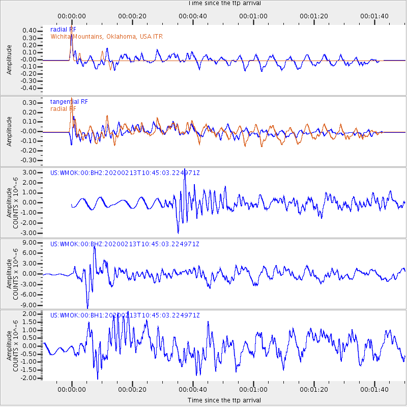
WMOK Wichita Mountains, Oklahoma, USA - Earthquake Result Viewer
*The percent match for this event was below the threshold and hence no stack was calculated.
| Earthquake location: |
Kuril Islands |
| Earthquake latitude/longitude: |
45.6/148.9 |
| Earthquake time(UTC): |
2020/02/13 (044) 10:33:44 GMT |
| Earthquake Depth: |
144 km |
| Earthquake Magnitude: |
7.0 mww |
| Earthquake Catalog/Contributor: |
NEIC PDE/us |
|
| Network: |
US United States National Seismic Network |
| Station: |
WMOK Wichita Mountains, Oklahoma, USA |
| Lat/Lon: |
34.74 N/98.78 W |
| Elevation: |
486 m |
|
| Distance: |
79.3 deg |
| Az: |
50.841 deg |
| Baz: |
318.651 deg |
| Ray Param: |
$rayparam |
*The percent match for this event was below the threshold and hence was not used in the summary stack. |
|
| Radial Match: |
72.206566 % |
| Radial Bump: |
400 |
| Transverse Match: |
50.81229 % |
| Transverse Bump: |
400 |
| SOD ConfigId: |
20792311 |
| Insert Time: |
2020-03-06 17:45:09.759 +0000 |
| GWidth: |
2.5 |
| Max Bumps: |
400 |
| Tol: |
0.001 |
|
Signal To Noise
| Channel | StoN | STA | LTA |
| US:WMOK:00:BHZ:20200213T10:45:03.224971Z | 4.2847843 | 1.3018972E-6 | 3.0384194E-7 |
| US:WMOK:00:BH1:20200213T10:45:03.224971Z | 0.8628036 | 2.53727E-7 | 2.9407275E-7 |
| US:WMOK:00:BH2:20200213T10:45:03.224971Z | 1.4061992 | 4.858329E-7 | 3.4549367E-7 |
| Arrivals |
| Ps | |
| PpPs | |
| PsPs/PpSs | |


