You are here: Home > Network List > UU - University of Utah Regional Network Stations List
> Station CVRU Castle Valley Ranch, Emery, UT, USA old TA-Q16A > Earthquake Result Viewer
CVRU Castle Valley Ranch, Emery, UT, USA old TA-Q16A - Earthquake Result Viewer
| Earthquake location: |
Kuril Islands |
| Earthquake latitude/longitude: |
45.6/148.9 |
| Earthquake time(UTC): |
2020/02/13 (044) 10:33:44 GMT |
| Earthquake Depth: |
144 km |
| Earthquake Magnitude: |
7.0 mww |
| Earthquake Catalog/Contributor: |
NEIC PDE/us |
|
| Network: |
UU University of Utah Regional Network |
| Station: |
CVRU Castle Valley Ranch, Emery, UT, USA old TA-Q16A |
| Lat/Lon: |
38.92 N/111.17 W |
| Elevation: |
1912 m |
|
| Distance: |
69.4 deg |
| Az: |
55.178 deg |
| Baz: |
312.406 deg |
| Ray Param: |
0.055288874 |
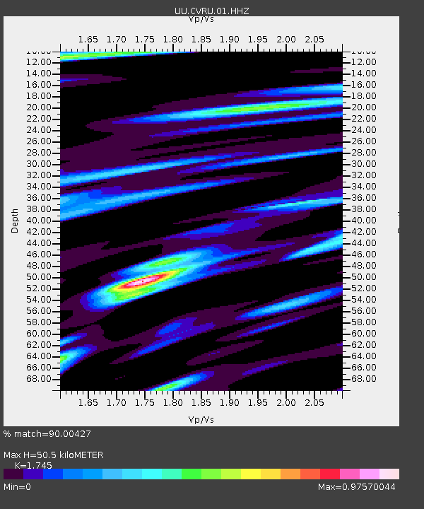
| Estimated Moho Depth: |
50.5 km |
| Estimated Crust Vp/Vs: |
1.75 |
| Assumed Crust Vp: |
6.207 km/s |
| Estimated Crust Vs: |
3.557 km/s |
| Estimated Crust Poisson's Ratio: |
0.26 |
|
| Radial Match: |
90.00427 % |
| Radial Bump: |
324 |
| Transverse Match: |
82.45337 % |
| Transverse Bump: |
375 |
| SOD ConfigId: |
20792311 |
| Insert Time: |
2020-03-06 17:46:05.145 +0000 |
| GWidth: |
2.5 |
| Max Bumps: |
400 |
| Tol: |
0.001 |
|
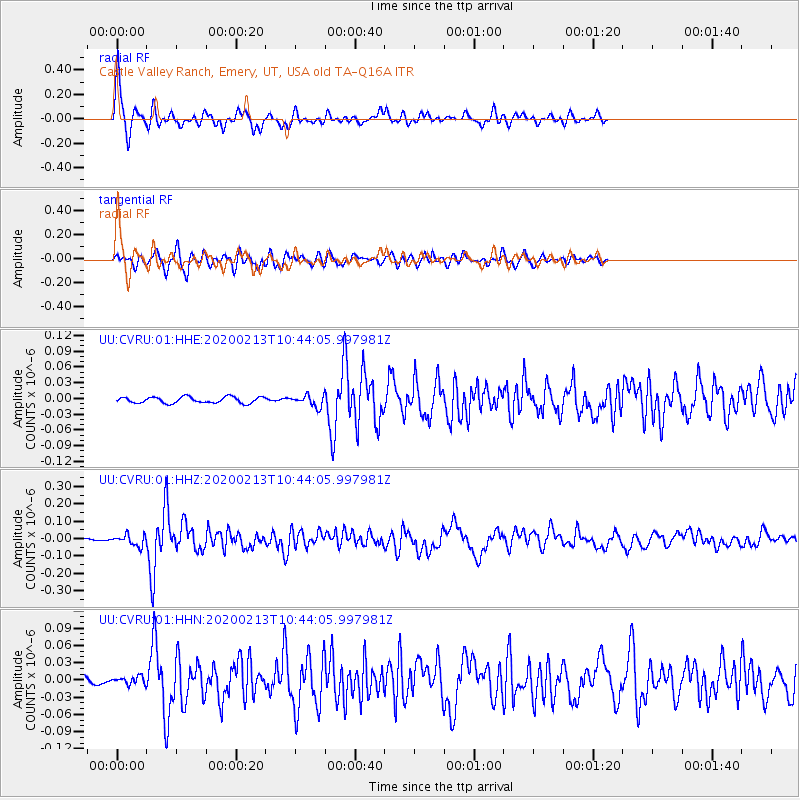
Signal To Noise
| Channel | StoN | STA | LTA |
| UU:CVRU:01:HHZ:20200213T10:44:05.997981Z | 3.7824643 | 3.0931567E-8 | 8.177623E-9 |
| UU:CVRU:01:HHN:20200213T10:44:05.997981Z | 1.2162172 | 6.6977153E-9 | 5.5070064E-9 |
| UU:CVRU:01:HHE:20200213T10:44:05.997981Z | 1.8049201 | 1.0443132E-8 | 5.7859246E-9 |
| Arrivals |
| Ps | 6.3 SECOND |
| PpPs | 22 SECOND |
| PsPs/PpSs | 28 SECOND |


