You are here: Home > Network List > UU - University of Utah Regional Network Stations List
> Station SVWY Solvay Mine, WY, USA > Earthquake Result Viewer
SVWY Solvay Mine, WY, USA - Earthquake Result Viewer
| Earthquake location: |
Kuril Islands |
| Earthquake latitude/longitude: |
45.6/148.9 |
| Earthquake time(UTC): |
2020/02/13 (044) 10:33:44 GMT |
| Earthquake Depth: |
144 km |
| Earthquake Magnitude: |
7.0 mww |
| Earthquake Catalog/Contributor: |
NEIC PDE/us |
|
| Network: |
UU University of Utah Regional Network |
| Station: |
SVWY Solvay Mine, WY, USA |
| Lat/Lon: |
41.45 N/109.86 W |
| Elevation: |
1950 m |
|
| Distance: |
68.4 deg |
| Az: |
52.452 deg |
| Baz: |
312.265 deg |
| Ray Param: |
0.055912927 |
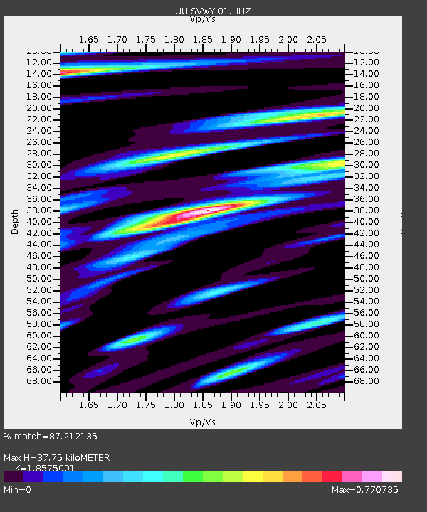
| Estimated Moho Depth: |
37.75 km |
| Estimated Crust Vp/Vs: |
1.86 |
| Assumed Crust Vp: |
6.207 km/s |
| Estimated Crust Vs: |
3.342 km/s |
| Estimated Crust Poisson's Ratio: |
0.30 |
|
| Radial Match: |
87.212135 % |
| Radial Bump: |
400 |
| Transverse Match: |
60.513943 % |
| Transverse Bump: |
365 |
| SOD ConfigId: |
20792311 |
| Insert Time: |
2020-03-06 17:48:19.376 +0000 |
| GWidth: |
2.5 |
| Max Bumps: |
400 |
| Tol: |
0.001 |
|

Signal To Noise
| Channel | StoN | STA | LTA |
| UU:SVWY:01:HHZ:20200213T10:44:00.059993Z | 5.0711417 | 7.178343E-8 | 1.415528E-8 |
| UU:SVWY:01:HHN:20200213T10:44:00.059993Z | 0.8903847 | 1.1874004E-8 | 1.3335814E-8 |
| UU:SVWY:01:HHE:20200213T10:44:00.059993Z | 3.2434957 | 2.2696177E-8 | 6.9974435E-9 |
| Arrivals |
| Ps | 5.4 SECOND |
| PpPs | 17 SECOND |
| PsPs/PpSs | 22 SECOND |


