You are here: Home > Network List > UW - Pacific Northwest Regional Seismic Network Stations List
> Station SHUK Shuksan (Mt. Baker Ski Area), WA > Earthquake Result Viewer
SHUK Shuksan (Mt. Baker Ski Area), WA - Earthquake Result Viewer
| Earthquake location: |
Kuril Islands |
| Earthquake latitude/longitude: |
45.6/148.9 |
| Earthquake time(UTC): |
2020/02/13 (044) 10:33:44 GMT |
| Earthquake Depth: |
144 km |
| Earthquake Magnitude: |
7.0 mww |
| Earthquake Catalog/Contributor: |
NEIC PDE/us |
|
| Network: |
UW Pacific Northwest Regional Seismic Network |
| Station: |
SHUK Shuksan (Mt. Baker Ski Area), WA |
| Lat/Lon: |
48.85 N/121.68 W |
| Elevation: |
1516 m |
|
| Distance: |
57.3 deg |
| Az: |
51.687 deg |
| Baz: |
303.536 deg |
| Ray Param: |
0.063119754 |
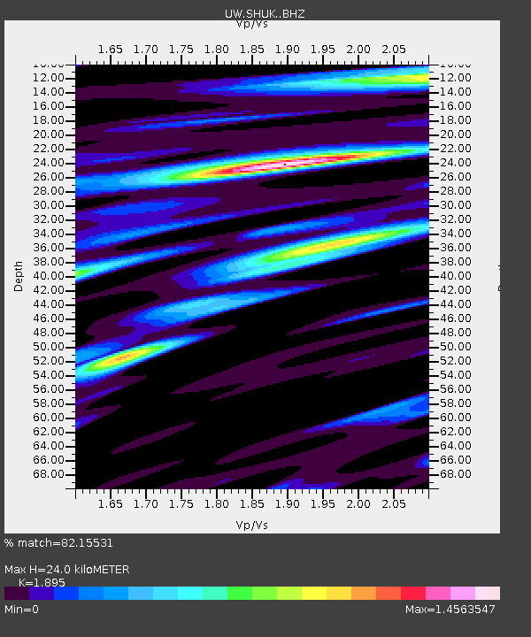
| Estimated Moho Depth: |
24.0 km |
| Estimated Crust Vp/Vs: |
1.89 |
| Assumed Crust Vp: |
6.566 km/s |
| Estimated Crust Vs: |
3.465 km/s |
| Estimated Crust Poisson's Ratio: |
0.31 |
|
| Radial Match: |
82.15531 % |
| Radial Bump: |
400 |
| Transverse Match: |
77.945465 % |
| Transverse Bump: |
400 |
| SOD ConfigId: |
20792311 |
| Insert Time: |
2020-03-06 17:54:31.398 +0000 |
| GWidth: |
2.5 |
| Max Bumps: |
400 |
| Tol: |
0.001 |
|

Signal To Noise
| Channel | StoN | STA | LTA |
| UW:SHUK: :BHZ:20200213T10:42:46.720027Z | 4.439446 | 3.0729527E-6 | 6.921928E-7 |
| UW:SHUK: :BHN:20200213T10:42:46.720027Z | 3.0738342 | 2.17143E-6 | 7.064239E-7 |
| UW:SHUK: :BHE:20200213T10:42:46.720027Z | 1.9592971 | 1.8285498E-6 | 9.3326827E-7 |
| Arrivals |
| Ps | 3.4 SECOND |
| PpPs | 10 SECOND |
| PsPs/PpSs | 14 SECOND |


