You are here: Home > Network List > WY - Yellowstone Wyoming Seismic Network Stations List
> Station YTP The Promontory, YNP, WY, USA > Earthquake Result Viewer
YTP The Promontory, YNP, WY, USA - Earthquake Result Viewer
| Earthquake location: |
Kuril Islands |
| Earthquake latitude/longitude: |
45.6/148.9 |
| Earthquake time(UTC): |
2020/02/13 (044) 10:33:44 GMT |
| Earthquake Depth: |
144 km |
| Earthquake Magnitude: |
7.0 mww |
| Earthquake Catalog/Contributor: |
NEIC PDE/us |
|
| Network: |
WY Yellowstone Wyoming Seismic Network |
| Station: |
YTP The Promontory, YNP, WY, USA |
| Lat/Lon: |
44.39 N/110.29 W |
| Elevation: |
2384 m |
|
| Distance: |
66.3 deg |
| Az: |
50.296 deg |
| Baz: |
311.15 deg |
| Ray Param: |
0.057329584 |
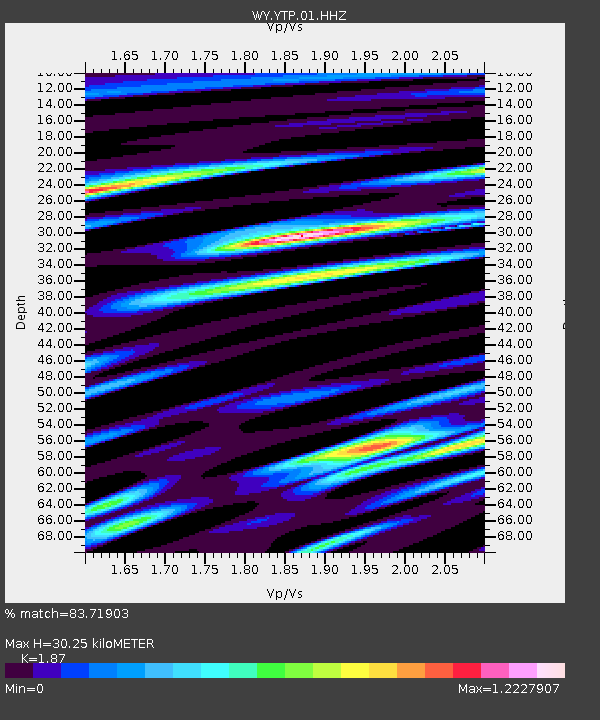
| Estimated Moho Depth: |
30.25 km |
| Estimated Crust Vp/Vs: |
1.87 |
| Assumed Crust Vp: |
6.35 km/s |
| Estimated Crust Vs: |
3.396 km/s |
| Estimated Crust Poisson's Ratio: |
0.30 |
|
| Radial Match: |
83.71903 % |
| Radial Bump: |
400 |
| Transverse Match: |
72.111206 % |
| Transverse Bump: |
400 |
| SOD ConfigId: |
20792311 |
| Insert Time: |
2020-03-06 18:01:18.415 +0000 |
| GWidth: |
2.5 |
| Max Bumps: |
400 |
| Tol: |
0.001 |
|

Signal To Noise
| Channel | StoN | STA | LTA |
| WY:YTP:01:HHZ:20200213T10:43:46.338008Z | 6.723416 | 4.4748116E-8 | 6.6555628E-9 |
| WY:YTP:01:HHN:20200213T10:43:46.338008Z | 1.9057105 | 1.69594E-8 | 8.899253E-9 |
| WY:YTP:01:HHE:20200213T10:43:46.338008Z | 1.2864621 | 1.3171312E-8 | 1.0238399E-8 |
| Arrivals |
| Ps | 4.3 SECOND |
| PpPs | 13 SECOND |
| PsPs/PpSs | 17 SECOND |


