You are here: Home > Network List > YX16 - Raton Basin UNM Broadband Network Stations List
> Station UNM5 Southernmost CO Station > Earthquake Result Viewer
UNM5 Southernmost CO Station - Earthquake Result Viewer
| Earthquake location: |
Kuril Islands |
| Earthquake latitude/longitude: |
45.6/148.9 |
| Earthquake time(UTC): |
2020/02/13 (044) 10:33:44 GMT |
| Earthquake Depth: |
144 km |
| Earthquake Magnitude: |
7.0 mww |
| Earthquake Catalog/Contributor: |
NEIC PDE/us |
|
| Network: |
YX Raton Basin UNM Broadband Network |
| Station: |
UNM5 Southernmost CO Station |
| Lat/Lon: |
37.12 N/104.78 W |
| Elevation: |
2035 m |
|
| Distance: |
74.3 deg |
| Az: |
52.846 deg |
| Baz: |
315.6 deg |
| Ray Param: |
0.052074376 |
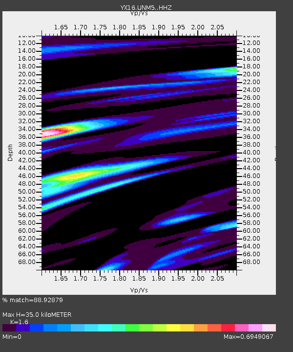
| Estimated Moho Depth: |
35.0 km |
| Estimated Crust Vp/Vs: |
1.60 |
| Assumed Crust Vp: |
6.316 km/s |
| Estimated Crust Vs: |
3.947 km/s |
| Estimated Crust Poisson's Ratio: |
0.18 |
|
| Radial Match: |
88.92879 % |
| Radial Bump: |
380 |
| Transverse Match: |
83.38523 % |
| Transverse Bump: |
327 |
| SOD ConfigId: |
20792311 |
| Insert Time: |
2020-03-06 18:08:53.386 +0000 |
| GWidth: |
2.5 |
| Max Bumps: |
400 |
| Tol: |
0.001 |
|

Signal To Noise
| Channel | StoN | STA | LTA |
| YX:UNM5: :HHZ:20200213T10:44:34.979976Z | 3.0083907 | 1.3063592E-6 | 4.3423856E-7 |
| YX:UNM5: :HHN:20200213T10:44:34.979976Z | 0.96365327 | 3.3659023E-7 | 3.492856E-7 |
| YX:UNM5: :HHE:20200213T10:44:34.979976Z | 1.0996282 | 5.544785E-7 | 5.0424177E-7 |
| Arrivals |
| Ps | 3.4 SECOND |
| PpPs | 14 SECOND |
| PsPs/PpSs | 17 SECOND |


