You are here: Home > Network List > US - United States National Seismic Network Stations List
> Station WMOK Wichita Mountains, Oklahoma, USA > Earthquake Result Viewer
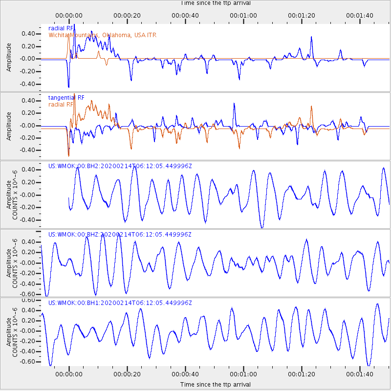
WMOK Wichita Mountains, Oklahoma, USA - Earthquake Result Viewer
*The percent match for this event was below the threshold and hence no stack was calculated.
| Earthquake location: |
Pacific-Antarctic Ridge |
| Earthquake latitude/longitude: |
-56.6/-142.3 |
| Earthquake time(UTC): |
2020/02/14 (045) 05:59:00 GMT |
| Earthquake Depth: |
10 km |
| Earthquake Magnitude: |
5.5 Mww |
| Earthquake Catalog/Contributor: |
NEIC PDE/us |
|
| Network: |
US United States National Seismic Network |
| Station: |
WMOK Wichita Mountains, Oklahoma, USA |
| Lat/Lon: |
34.74 N/98.78 W |
| Elevation: |
486 m |
|
| Distance: |
98.2 deg |
| Az: |
34.945 deg |
| Baz: |
202.603 deg |
| Ray Param: |
$rayparam |
*The percent match for this event was below the threshold and hence was not used in the summary stack. |
|
| Radial Match: |
64.97334 % |
| Radial Bump: |
400 |
| Transverse Match: |
64.743195 % |
| Transverse Bump: |
400 |
| SOD ConfigId: |
20792311 |
| Insert Time: |
2020-03-07 12:59:59.430 +0000 |
| GWidth: |
2.5 |
| Max Bumps: |
400 |
| Tol: |
0.001 |
|
Signal To Noise
| Channel | StoN | STA | LTA |
| US:WMOK:00:BHZ:20200214T06:12:05.449996Z | 0.3244651 | 1.4004571E-7 | 4.3162026E-7 |
| US:WMOK:00:BH1:20200214T06:12:05.449996Z | 0.83699936 | 3.1722038E-7 | 3.7899716E-7 |
| US:WMOK:00:BH2:20200214T06:12:05.449996Z | 0.8153708 | 1.8761729E-7 | 2.3010058E-7 |
| Arrivals |
| Ps | |
| PpPs | |
| PsPs/PpSs | |


