You are here: Home > Network List > TS - TERRAscope (Southern California Seismic Network) Stations List
> Station PFO Pinon Flat, California, USA > Earthquake Result Viewer
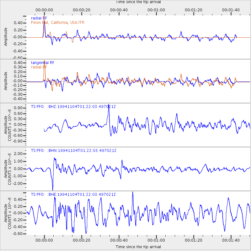
PFO Pinon Flat, California, USA - Earthquake Result Viewer
*The percent match for this event was below the threshold and hence no stack was calculated.
| Earthquake location: |
Peru-Brazil Border Region |
| Earthquake latitude/longitude: |
-9.3/-71.3 |
| Earthquake time(UTC): |
1994/11/04 (308) 01:13:20 GMT |
| Earthquake Depth: |
598 km |
| Earthquake Magnitude: |
5.8 MB, 5.9 UNKNOWN, 6.2 MW |
| Earthquake Catalog/Contributor: |
WHDF/NEIC |
|
| Network: |
TS TERRAscope (Southern California Seismic Network) |
| Station: |
PFO Pinon Flat, California, USA |
| Lat/Lon: |
33.61 N/116.46 W |
| Elevation: |
1280 m |
|
| Distance: |
60.5 deg |
| Az: |
317.185 deg |
| Baz: |
126.511 deg |
| Ray Param: |
$rayparam |
*The percent match for this event was below the threshold and hence was not used in the summary stack. |
|
| Radial Match: |
71.753914 % |
| Radial Bump: |
400 |
| Transverse Match: |
73.609924 % |
| Transverse Bump: |
400 |
| SOD ConfigId: |
4480 |
| Insert Time: |
2010-02-26 14:43:10.362 +0000 |
| GWidth: |
2.5 |
| Max Bumps: |
400 |
| Tol: |
0.001 |
|
Signal To Noise
| Channel | StoN | STA | LTA |
| TS:PFO: :BHN:19941104T01:22:03.497021Z | 4.796107 | 8.5394845E-7 | 1.7805034E-7 |
| TS:PFO: :BHE:19941104T01:22:03.497021Z | 1.2049731 | 1.3743505E-7 | 1.14056526E-7 |
| TS:PFO: :BHZ:19941104T01:22:03.497021Z | 2.6560848 | 3.854372E-7 | 1.451148E-7 |
| Arrivals |
| Ps | |
| PpPs | |
| PsPs/PpSs | |


