You are here: Home > Network List > AV - Alaska Volcano Observatory Stations List
> Station SPCR Ckakachatna River, Mount Spurr, Alaska > Earthquake Result Viewer
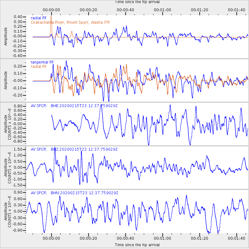
SPCR Ckakachatna River, Mount Spurr, Alaska - Earthquake Result Viewer
*The percent match for this event was below the threshold and hence no stack was calculated.
| Earthquake location: |
Irian Jaya Region, Indonesia |
| Earthquake latitude/longitude: |
-3.4/131.5 |
| Earthquake time(UTC): |
2020/02/15 (046) 23:00:28 GMT |
| Earthquake Depth: |
19 km |
| Earthquake Magnitude: |
5.6 mww |
| Earthquake Catalog/Contributor: |
NEIC PDE/us |
|
| Network: |
AV Alaska Volcano Observatory |
| Station: |
SPCR Ckakachatna River, Mount Spurr, Alaska |
| Lat/Lon: |
61.20 N/152.21 W |
| Elevation: |
984 m |
|
| Distance: |
86.4 deg |
| Az: |
28.126 deg |
| Baz: |
256.37 deg |
| Ray Param: |
$rayparam |
*The percent match for this event was below the threshold and hence was not used in the summary stack. |
|
| Radial Match: |
50.97549 % |
| Radial Bump: |
400 |
| Transverse Match: |
60.500935 % |
| Transverse Bump: |
400 |
| SOD ConfigId: |
20831131 |
| Insert Time: |
2020-03-10 19:56:05.450 +0000 |
| GWidth: |
2.5 |
| Max Bumps: |
400 |
| Tol: |
0.001 |
|
Signal To Noise
| Channel | StoN | STA | LTA |
| AV:SPCR: :BHZ:20200215T23:12:37.759029Z | 2.7823894 | 6.937417E-7 | 2.4933308E-7 |
| AV:SPCR: :BHN:20200215T23:12:37.759029Z | 1.9684609 | 4.3797672E-7 | 2.2249705E-7 |
| AV:SPCR: :BHE:20200215T23:12:37.759029Z | 1.8395027 | 3.6153727E-7 | 1.9654077E-7 |
| Arrivals |
| Ps | |
| PpPs | |
| PsPs/PpSs | |


