You are here: Home > Network List > US - United States National Seismic Network Stations List
> Station DUG Dugway, Tooele County, Utah, USA > Earthquake Result Viewer
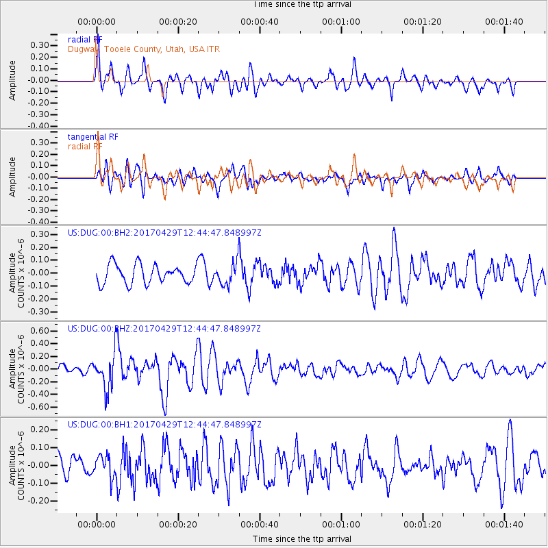
DUG Dugway, Tooele County, Utah, USA - Earthquake Result Viewer
*The percent match for this event was below the threshold and hence no stack was calculated.
| Earthquake location: |
Kyushu, Japan |
| Earthquake latitude/longitude: |
30.8/131.4 |
| Earthquake time(UTC): |
2017/04/29 (119) 12:32:32 GMT |
| Earthquake Depth: |
21 km |
| Earthquake Magnitude: |
5.7 Mww |
| Earthquake Catalog/Contributor: |
NEIC PDE/us |
|
| Network: |
US United States National Seismic Network |
| Station: |
DUG Dugway, Tooele County, Utah, USA |
| Lat/Lon: |
40.19 N/112.81 W |
| Elevation: |
1477 m |
|
| Distance: |
87.6 deg |
| Az: |
43.667 deg |
| Baz: |
309.147 deg |
| Ray Param: |
$rayparam |
*The percent match for this event was below the threshold and hence was not used in the summary stack. |
|
| Radial Match: |
68.44202 % |
| Radial Bump: |
400 |
| Transverse Match: |
54.64309 % |
| Transverse Bump: |
400 |
| SOD ConfigId: |
2028011 |
| Insert Time: |
2017-05-13 12:37:12.084 +0000 |
| GWidth: |
2.5 |
| Max Bumps: |
400 |
| Tol: |
0.001 |
|
Signal To Noise
| Channel | StoN | STA | LTA |
| US:DUG:00:BHZ:20170429T12:44:47.848997Z | 5.5265803 | 2.9102318E-7 | 5.2658816E-8 |
| US:DUG:00:BH1:20170429T12:44:47.848997Z | 1.1018074 | 5.980994E-8 | 5.428348E-8 |
| US:DUG:00:BH2:20170429T12:44:47.848997Z | 1.1797317 | 8.653987E-8 | 7.335555E-8 |
| Arrivals |
| Ps | |
| PpPs | |
| PsPs/PpSs | |


