You are here: Home > Network List > US - United States National Seismic Network Stations List
> Station EGMT Eagleton, Montana, USA > Earthquake Result Viewer
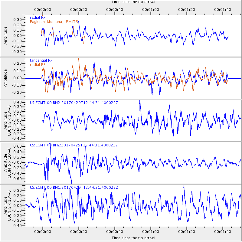
EGMT Eagleton, Montana, USA - Earthquake Result Viewer
*The percent match for this event was below the threshold and hence no stack was calculated.
| Earthquake location: |
Kyushu, Japan |
| Earthquake latitude/longitude: |
30.8/131.4 |
| Earthquake time(UTC): |
2017/04/29 (119) 12:32:32 GMT |
| Earthquake Depth: |
21 km |
| Earthquake Magnitude: |
5.7 Mww |
| Earthquake Catalog/Contributor: |
NEIC PDE/us |
|
| Network: |
US United States National Seismic Network |
| Station: |
EGMT Eagleton, Montana, USA |
| Lat/Lon: |
48.02 N/109.75 W |
| Elevation: |
1055 m |
|
| Distance: |
84.3 deg |
| Az: |
36.235 deg |
| Baz: |
310.75 deg |
| Ray Param: |
$rayparam |
*The percent match for this event was below the threshold and hence was not used in the summary stack. |
|
| Radial Match: |
61.865986 % |
| Radial Bump: |
400 |
| Transverse Match: |
52.461716 % |
| Transverse Bump: |
400 |
| SOD ConfigId: |
2028011 |
| Insert Time: |
2017-05-13 12:37:17.181 +0000 |
| GWidth: |
2.5 |
| Max Bumps: |
400 |
| Tol: |
0.001 |
|
Signal To Noise
| Channel | StoN | STA | LTA |
| US:EGMT:00:BHZ:20170429T12:44:31.400022Z | 5.5321603 | 3.878085E-7 | 7.010074E-8 |
| US:EGMT:00:BH1:20170429T12:44:31.400022Z | 3.3379064 | 2.3458324E-7 | 7.027855E-8 |
| US:EGMT:00:BH2:20170429T12:44:31.400022Z | 0.6251617 | 6.65492E-8 | 1.0645117E-7 |
| Arrivals |
| Ps | |
| PpPs | |
| PsPs/PpSs | |


