You are here: Home > Network List > TA - USArray Transportable Network (new EarthScope stations) Stations List
> Station F21K Alatna River, AK, USA > Earthquake Result Viewer
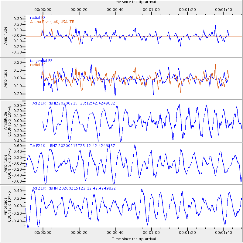
F21K Alatna River, AK, USA - Earthquake Result Viewer
*The percent match for this event was below the threshold and hence no stack was calculated.
| Earthquake location: |
Irian Jaya Region, Indonesia |
| Earthquake latitude/longitude: |
-3.4/131.5 |
| Earthquake time(UTC): |
2020/02/15 (046) 23:00:28 GMT |
| Earthquake Depth: |
19 km |
| Earthquake Magnitude: |
5.6 mww |
| Earthquake Catalog/Contributor: |
NEIC PDE/us |
|
| Network: |
TA USArray Transportable Network (new EarthScope stations) |
| Station: |
F21K Alatna River, AK, USA |
| Lat/Lon: |
67.22 N/153.48 W |
| Elevation: |
597 m |
|
| Distance: |
87.4 deg |
| Az: |
22.122 deg |
| Baz: |
254.895 deg |
| Ray Param: |
$rayparam |
*The percent match for this event was below the threshold and hence was not used in the summary stack. |
|
| Radial Match: |
57.685226 % |
| Radial Bump: |
384 |
| Transverse Match: |
49.35917 % |
| Transverse Bump: |
400 |
| SOD ConfigId: |
20831131 |
| Insert Time: |
2020-03-10 22:27:33.011 +0000 |
| GWidth: |
2.5 |
| Max Bumps: |
400 |
| Tol: |
0.001 |
|
Signal To Noise
| Channel | StoN | STA | LTA |
| TA:F21K: :BHZ:20200215T23:12:42.424983Z | 2.300062 | 4.2013266E-7 | 1.8266147E-7 |
| TA:F21K: :BHN:20200215T23:12:42.424983Z | 0.69986904 | 1.4151173E-7 | 2.0219746E-7 |
| TA:F21K: :BHE:20200215T23:12:42.424983Z | 1.1902721 | 2.1676E-7 | 1.8210962E-7 |
| Arrivals |
| Ps | |
| PpPs | |
| PsPs/PpSs | |


