You are here: Home > Network List > TA - USArray Transportable Network (new EarthScope stations) Stations List
> Station I17K Unalakleet, AK, USA > Earthquake Result Viewer
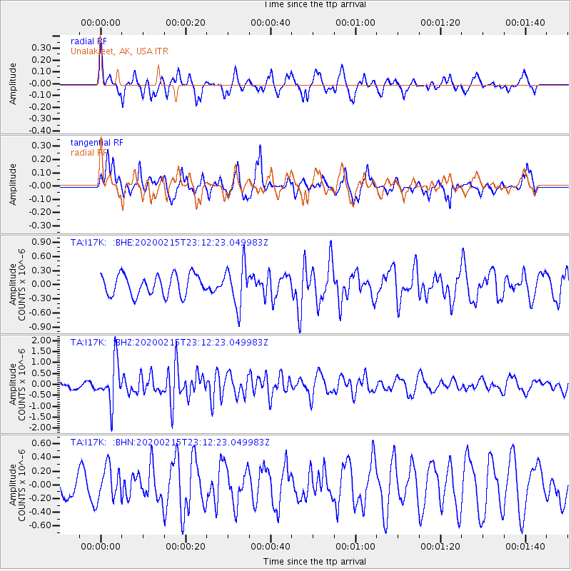
I17K Unalakleet, AK, USA - Earthquake Result Viewer
*The percent match for this event was below the threshold and hence no stack was calculated.
| Earthquake location: |
Irian Jaya Region, Indonesia |
| Earthquake latitude/longitude: |
-3.4/131.5 |
| Earthquake time(UTC): |
2020/02/15 (046) 23:00:28 GMT |
| Earthquake Depth: |
19 km |
| Earthquake Magnitude: |
5.6 mww |
| Earthquake Catalog/Contributor: |
NEIC PDE/us |
|
| Network: |
TA USArray Transportable Network (new EarthScope stations) |
| Station: |
I17K Unalakleet, AK, USA |
| Lat/Lon: |
63.89 N/160.70 W |
| Elevation: |
105 m |
|
| Distance: |
83.5 deg |
| Az: |
24.362 deg |
| Baz: |
248.513 deg |
| Ray Param: |
$rayparam |
*The percent match for this event was below the threshold and hence was not used in the summary stack. |
|
| Radial Match: |
58.705406 % |
| Radial Bump: |
340 |
| Transverse Match: |
62.12002 % |
| Transverse Bump: |
380 |
| SOD ConfigId: |
20831131 |
| Insert Time: |
2020-03-10 22:30:24.307 +0000 |
| GWidth: |
2.5 |
| Max Bumps: |
400 |
| Tol: |
0.001 |
|
Signal To Noise
| Channel | StoN | STA | LTA |
| TA:I17K: :BHZ:20200215T23:12:23.049983Z | 4.639405 | 9.566724E-7 | 2.0620583E-7 |
| TA:I17K: :BHN:20200215T23:12:23.049983Z | 0.81548256 | 2.4242817E-7 | 2.9728187E-7 |
| TA:I17K: :BHE:20200215T23:12:23.049983Z | 2.0548928 | 4.4640407E-7 | 2.1723959E-7 |
| Arrivals |
| Ps | |
| PpPs | |
| PsPs/PpSs | |


