You are here: Home > Network List > TA - USArray Transportable Network (new EarthScope stations) Stations List
> Station K15K Wolf Creek Mountain, AK, USA > Earthquake Result Viewer
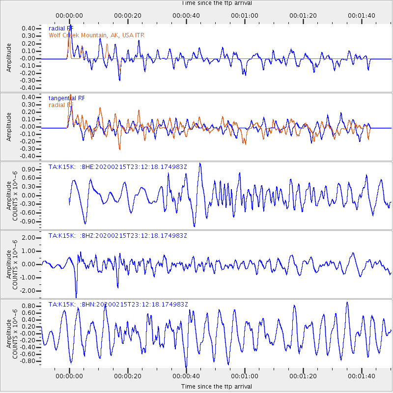
K15K Wolf Creek Mountain, AK, USA - Earthquake Result Viewer
*The percent match for this event was below the threshold and hence no stack was calculated.
| Earthquake location: |
Irian Jaya Region, Indonesia |
| Earthquake latitude/longitude: |
-3.4/131.5 |
| Earthquake time(UTC): |
2020/02/15 (046) 23:00:28 GMT |
| Earthquake Depth: |
19 km |
| Earthquake Magnitude: |
5.6 mww |
| Earthquake Catalog/Contributor: |
NEIC PDE/us |
|
| Network: |
TA USArray Transportable Network (new EarthScope stations) |
| Station: |
K15K Wolf Creek Mountain, AK, USA |
| Lat/Lon: |
62.29 N/161.53 W |
| Elevation: |
346 m |
|
| Distance: |
82.5 deg |
| Az: |
25.716 deg |
| Baz: |
247.934 deg |
| Ray Param: |
$rayparam |
*The percent match for this event was below the threshold and hence was not used in the summary stack. |
|
| Radial Match: |
68.41553 % |
| Radial Bump: |
400 |
| Transverse Match: |
48.08903 % |
| Transverse Bump: |
400 |
| SOD ConfigId: |
20831131 |
| Insert Time: |
2020-03-10 22:31:18.793 +0000 |
| GWidth: |
2.5 |
| Max Bumps: |
400 |
| Tol: |
0.001 |
|
Signal To Noise
| Channel | StoN | STA | LTA |
| TA:K15K: :BHZ:20200215T23:12:18.174983Z | 3.2352233 | 8.1806513E-7 | 2.5286204E-7 |
| TA:K15K: :BHN:20200215T23:12:18.174983Z | 1.9035405 | 5.00973E-7 | 2.631796E-7 |
| TA:K15K: :BHE:20200215T23:12:18.174983Z | 0.9734277 | 3.3019597E-7 | 3.3920955E-7 |
| Arrivals |
| Ps | |
| PpPs | |
| PsPs/PpSs | |


