You are here: Home > Network List > TA - USArray Transportable Network (new EarthScope stations) Stations List
> Station E20K Nigu River, AK, USA > Earthquake Result Viewer
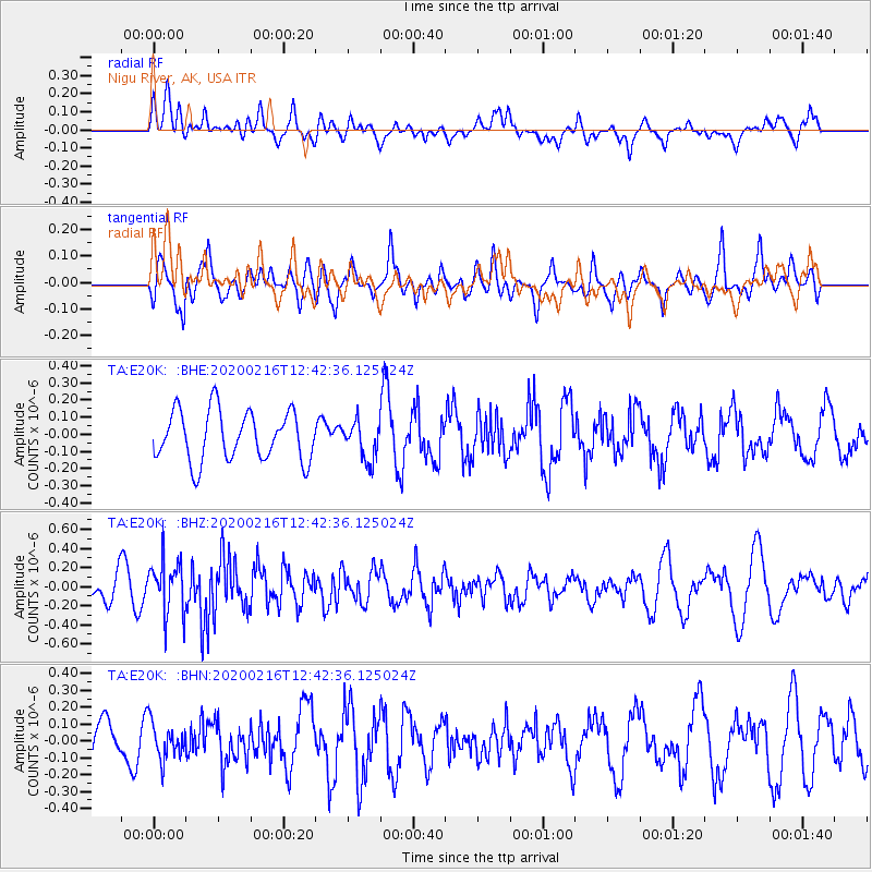
E20K Nigu River, AK, USA - Earthquake Result Viewer
*The percent match for this event was below the threshold and hence no stack was calculated.
| Earthquake location: |
Southern Iran |
| Earthquake latitude/longitude: |
27.1/55.8 |
| Earthquake time(UTC): |
2020/02/16 (047) 12:30:47 GMT |
| Earthquake Depth: |
10 km |
| Earthquake Magnitude: |
5.1 Mww |
| Earthquake Catalog/Contributor: |
NEIC PDE/us |
|
| Network: |
TA USArray Transportable Network (new EarthScope stations) |
| Station: |
E20K Nigu River, AK, USA |
| Lat/Lon: |
68.26 N/156.19 W |
| Elevation: |
866 m |
|
| Distance: |
82.0 deg |
| Az: |
11.487 deg |
| Baz: |
331.546 deg |
| Ray Param: |
$rayparam |
*The percent match for this event was below the threshold and hence was not used in the summary stack. |
|
| Radial Match: |
54.486336 % |
| Radial Bump: |
400 |
| Transverse Match: |
54.009796 % |
| Transverse Bump: |
366 |
| SOD ConfigId: |
20831131 |
| Insert Time: |
2020-03-13 00:24:03.777 +0000 |
| GWidth: |
2.5 |
| Max Bumps: |
400 |
| Tol: |
0.001 |
|
Signal To Noise
| Channel | StoN | STA | LTA |
| TA:E20K: :BHZ:20200216T12:42:36.125024Z | 2.2072675 | 2.7641573E-7 | 1.2522982E-7 |
| TA:E20K: :BHN:20200216T12:42:36.125024Z | 0.6229177 | 1.0566615E-7 | 1.69631E-7 |
| TA:E20K: :BHE:20200216T12:42:36.125024Z | 0.76267594 | 1.10551916E-7 | 1.4495268E-7 |
| Arrivals |
| Ps | |
| PpPs | |
| PsPs/PpSs | |


