You are here: Home > Network List > TA - USArray Transportable Network (new EarthScope stations) Stations List
> Station G21K Allakaket, AK, USA > Earthquake Result Viewer
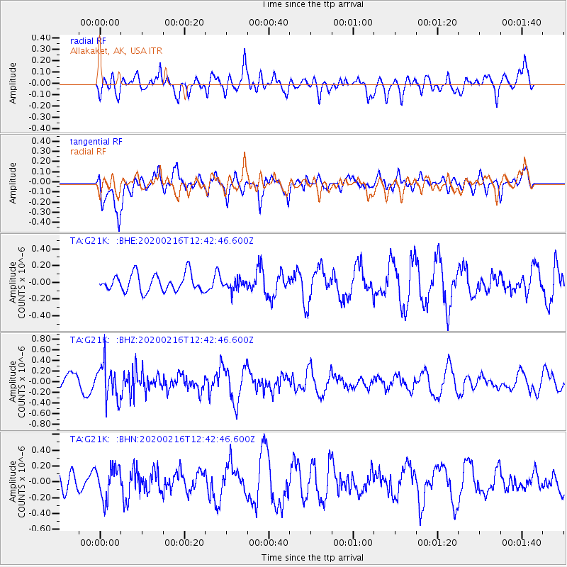
G21K Allakaket, AK, USA - Earthquake Result Viewer
*The percent match for this event was below the threshold and hence no stack was calculated.
| Earthquake location: |
Southern Iran |
| Earthquake latitude/longitude: |
27.1/55.8 |
| Earthquake time(UTC): |
2020/02/16 (047) 12:30:47 GMT |
| Earthquake Depth: |
10 km |
| Earthquake Magnitude: |
5.1 Mww |
| Earthquake Catalog/Contributor: |
NEIC PDE/us |
|
| Network: |
TA USArray Transportable Network (new EarthScope stations) |
| Station: |
G21K Allakaket, AK, USA |
| Lat/Lon: |
66.52 N/153.51 W |
| Elevation: |
446 m |
|
| Distance: |
84.1 deg |
| Az: |
11.364 deg |
| Baz: |
334.006 deg |
| Ray Param: |
$rayparam |
*The percent match for this event was below the threshold and hence was not used in the summary stack. |
|
| Radial Match: |
64.64376 % |
| Radial Bump: |
400 |
| Transverse Match: |
56.54589 % |
| Transverse Bump: |
400 |
| SOD ConfigId: |
20831131 |
| Insert Time: |
2020-03-13 00:26:46.208 +0000 |
| GWidth: |
2.5 |
| Max Bumps: |
400 |
| Tol: |
0.001 |
|
Signal To Noise
| Channel | StoN | STA | LTA |
| TA:G21K: :BHZ:20200216T12:42:46.600Z | 2.0203402 | 3.278165E-7 | 1.6225806E-7 |
| TA:G21K: :BHN:20200216T12:42:46.600Z | 1.4356959 | 1.9700259E-7 | 1.372175E-7 |
| TA:G21K: :BHE:20200216T12:42:46.600Z | 0.6173596 | 6.33871E-8 | 1.0267452E-7 |
| Arrivals |
| Ps | |
| PpPs | |
| PsPs/PpSs | |


