You are here: Home > Network List > TA - USArray Transportable Network (new EarthScope stations) Stations List
> Station I30M Mount Dempster, Yukon, CAN > Earthquake Result Viewer
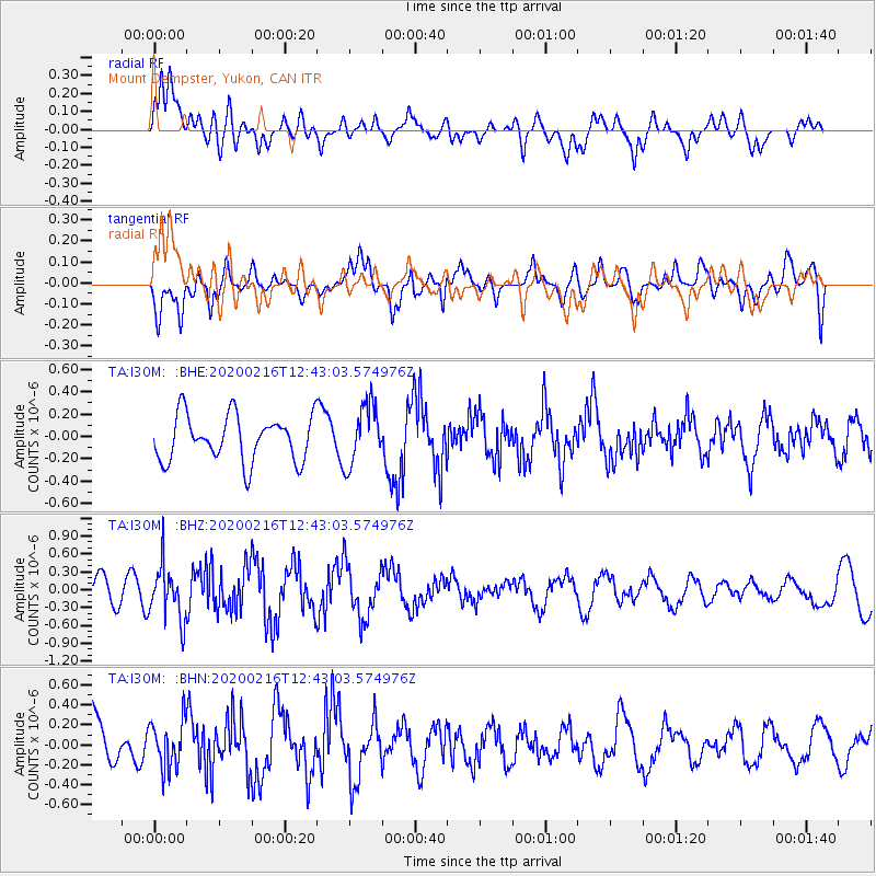
I30M Mount Dempster, Yukon, CAN - Earthquake Result Viewer
*The percent match for this event was below the threshold and hence no stack was calculated.
| Earthquake location: |
Southern Iran |
| Earthquake latitude/longitude: |
27.1/55.8 |
| Earthquake time(UTC): |
2020/02/16 (047) 12:30:47 GMT |
| Earthquake Depth: |
10 km |
| Earthquake Magnitude: |
5.1 Mww |
| Earthquake Catalog/Contributor: |
NEIC PDE/us |
|
| Network: |
TA USArray Transportable Network (new EarthScope stations) |
| Station: |
I30M Mount Dempster, Yukon, CAN |
| Lat/Lon: |
65.22 N/136.38 W |
| Elevation: |
1399 m |
|
| Distance: |
87.5 deg |
| Az: |
5.092 deg |
| Baz: |
349.178 deg |
| Ray Param: |
$rayparam |
*The percent match for this event was below the threshold and hence was not used in the summary stack. |
|
| Radial Match: |
56.100964 % |
| Radial Bump: |
400 |
| Transverse Match: |
45.376884 % |
| Transverse Bump: |
400 |
| SOD ConfigId: |
20831131 |
| Insert Time: |
2020-03-13 00:28:54.108 +0000 |
| GWidth: |
2.5 |
| Max Bumps: |
400 |
| Tol: |
0.001 |
|
Signal To Noise
| Channel | StoN | STA | LTA |
| TA:I30M: :BHZ:20200216T12:43:03.574976Z | 2.3720047 | 4.4788408E-7 | 1.888209E-7 |
| TA:I30M: :BHN:20200216T12:43:03.574976Z | 0.9363299 | 2.3627302E-7 | 2.523395E-7 |
| TA:I30M: :BHE:20200216T12:43:03.574976Z | 1.3197997 | 2.6927353E-7 | 2.0402607E-7 |
| Arrivals |
| Ps | |
| PpPs | |
| PsPs/PpSs | |


