You are here: Home > Network List > CI - Caltech Regional Seismic Network Stations List
> Station GLA Glamis, Glamis, CA, USA > Earthquake Result Viewer
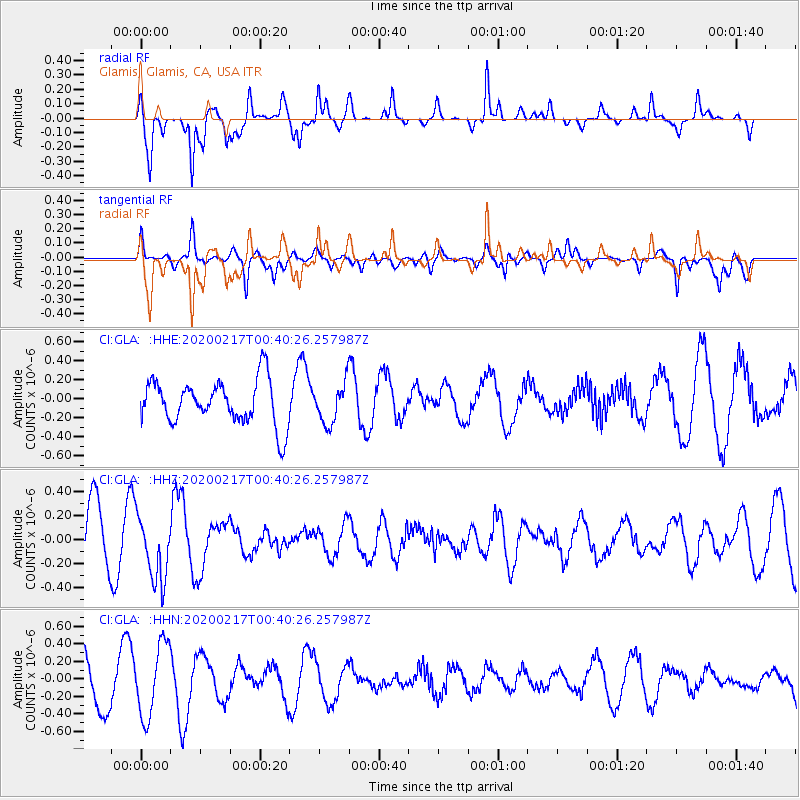
GLA Glamis, Glamis, CA, USA - Earthquake Result Viewer
*The percent match for this event was below the threshold and hence no stack was calculated.
| Earthquake location: |
South Of Kermadec Islands |
| Earthquake latitude/longitude: |
-33.1/179.9 |
| Earthquake time(UTC): |
2020/02/17 (048) 00:28:15 GMT |
| Earthquake Depth: |
149 km |
| Earthquake Magnitude: |
5.5 Mww |
| Earthquake Catalog/Contributor: |
NEIC PDE/us |
|
| Network: |
CI Caltech Regional Seismic Network |
| Station: |
GLA Glamis, Glamis, CA, USA |
| Lat/Lon: |
33.05 N/114.83 W |
| Elevation: |
610 m |
|
| Distance: |
90.0 deg |
| Az: |
49.689 deg |
| Baz: |
229.669 deg |
| Ray Param: |
$rayparam |
*The percent match for this event was below the threshold and hence was not used in the summary stack. |
|
| Radial Match: |
65.574165 % |
| Radial Bump: |
304 |
| Transverse Match: |
63.775257 % |
| Transverse Bump: |
326 |
| SOD ConfigId: |
20831131 |
| Insert Time: |
2020-03-13 18:39:26.846 +0000 |
| GWidth: |
2.5 |
| Max Bumps: |
400 |
| Tol: |
0.001 |
|
Signal To Noise
| Channel | StoN | STA | LTA |
| CI:GLA: :HHZ:20200217T00:40:26.257987Z | 0.91990715 | 2.7615332E-7 | 3.0019694E-7 |
| CI:GLA: :HHN:20200217T00:40:26.257987Z | 1.7465782 | 4.1510006E-7 | 2.3766474E-7 |
| CI:GLA: :HHE:20200217T00:40:26.257987Z | 0.8945701 | 2.0977905E-7 | 2.3450265E-7 |
| Arrivals |
| Ps | |
| PpPs | |
| PsPs/PpSs | |


