You are here: Home > Network List > CI - Caltech Regional Seismic Network Stations List
> Station MPM Manuel Prospect Mine, California, USA > Earthquake Result Viewer
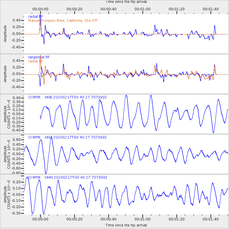
MPM Manuel Prospect Mine, California, USA - Earthquake Result Viewer
*The percent match for this event was below the threshold and hence no stack was calculated.
| Earthquake location: |
South Of Kermadec Islands |
| Earthquake latitude/longitude: |
-33.1/179.9 |
| Earthquake time(UTC): |
2020/02/17 (048) 00:28:15 GMT |
| Earthquake Depth: |
149 km |
| Earthquake Magnitude: |
5.5 Mww |
| Earthquake Catalog/Contributor: |
NEIC PDE/us |
|
| Network: |
CI Caltech Regional Seismic Network |
| Station: |
MPM Manuel Prospect Mine, California, USA |
| Lat/Lon: |
36.06 N/117.49 W |
| Elevation: |
185 m |
|
| Distance: |
90.3 deg |
| Az: |
45.985 deg |
| Baz: |
228.173 deg |
| Ray Param: |
$rayparam |
*The percent match for this event was below the threshold and hence was not used in the summary stack. |
|
| Radial Match: |
65.37748 % |
| Radial Bump: |
400 |
| Transverse Match: |
53.22185 % |
| Transverse Bump: |
400 |
| SOD ConfigId: |
20831131 |
| Insert Time: |
2020-03-13 18:47:13.473 +0000 |
| GWidth: |
2.5 |
| Max Bumps: |
400 |
| Tol: |
0.001 |
|
Signal To Noise
| Channel | StoN | STA | LTA |
| CI:MPM: :HHZ:20200217T00:40:27.707999Z | 3.3249836 | 5.1197657E-7 | 1.5397869E-7 |
| CI:MPM: :HHN:20200217T00:40:27.707999Z | 1.2693748 | 1.927598E-7 | 1.5185411E-7 |
| CI:MPM: :HHE:20200217T00:40:27.707999Z | 1.0060747 | 2.0226612E-7 | 2.0104484E-7 |
| Arrivals |
| Ps | |
| PpPs | |
| PsPs/PpSs | |


