You are here: Home > Network List > MN - MEDNET Project Stations List
> Station WDD Wield Dalam, Malta > Earthquake Result Viewer
WDD Wield Dalam, Malta - Earthquake Result Viewer
| Earthquake location: |
Baffin Bay |
| Earthquake latitude/longitude: |
75.4/-72.5 |
| Earthquake time(UTC): |
2009/07/07 (188) 19:11:46 GMT |
| Earthquake Depth: |
19 km |
| Earthquake Magnitude: |
5.9 MB, 5.7 MS, 6.1 MW, 6.0 MW |
| Earthquake Catalog/Contributor: |
WHDF/NEIC |
|
| Network: |
MN MEDNET Project |
| Station: |
WDD Wield Dalam, Malta |
| Lat/Lon: |
35.87 N/14.52 E |
| Elevation: |
41 m |
|
| Distance: |
54.9 deg |
| Az: |
82.484 deg |
| Baz: |
341.903 deg |
| Ray Param: |
0.06512941 |
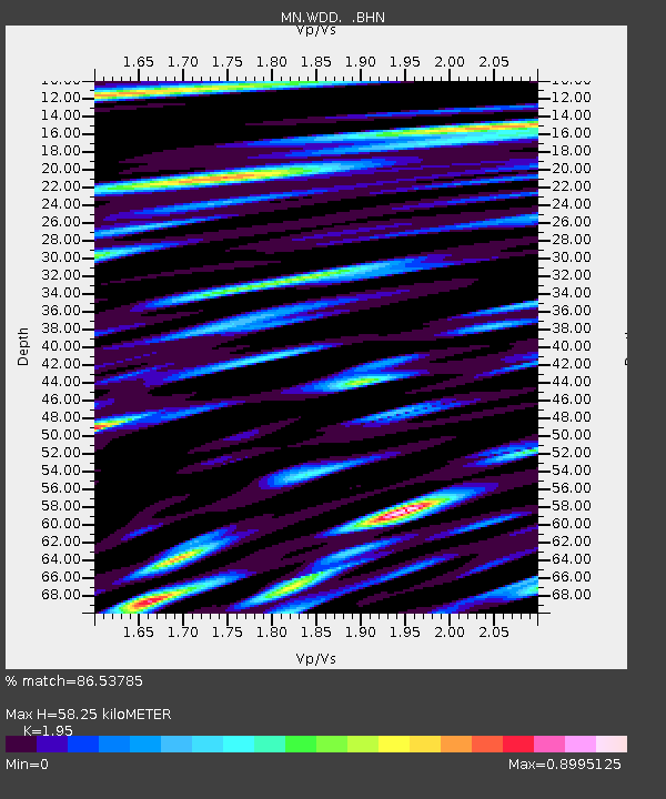
| Estimated Moho Depth: |
58.25 km |
| Estimated Crust Vp/Vs: |
1.95 |
| Assumed Crust Vp: |
4.05 km/s |
| Estimated Crust Vs: |
2.077 km/s |
| Estimated Crust Poisson's Ratio: |
0.32 |
|
| Radial Match: |
86.53785 % |
| Radial Bump: |
400 |
| Transverse Match: |
80.18177 % |
| Transverse Bump: |
400 |
| SOD ConfigId: |
2648 |
| Insert Time: |
2010-03-08 18:01:23.279 +0000 |
| GWidth: |
2.5 |
| Max Bumps: |
400 |
| Tol: |
0.001 |
|
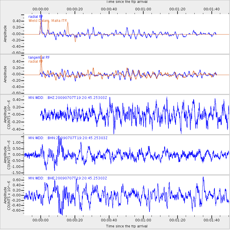
Signal To Noise
| Channel | StoN | STA | LTA |
| MN:WDD: :BHN:20090707T19:20:45.25303Z | 5.224023 | 5.406467E-7 | 1.034924E-7 |
| MN:WDD: :BHE:20090707T19:20:45.25303Z | 3.2423 | 2.6989903E-7 | 8.324308E-8 |
| MN:WDD: :BHZ:20090707T19:20:45.25303Z | 1.4028784 | 1.2705651E-7 | 9.056844E-8 |
| Arrivals |
| Ps | 14 SECOND |
| PpPs | 42 SECOND |
| PsPs/PpSs | 56 SECOND |


