You are here: Home > Network List > MN - MEDNET Project Stations List
> Station WDD Wield Dalam, Malta > Earthquake Result Viewer
WDD Wield Dalam, Malta - Earthquake Result Viewer
| Earthquake location: |
Kuril Islands |
| Earthquake latitude/longitude: |
46.6/153.3 |
| Earthquake time(UTC): |
2006/11/15 (319) 11:14:13 GMT |
| Earthquake Depth: |
10 km |
| Earthquake Magnitude: |
6.5 MB, 7.8 MS, 8.3 MW, 7.9 MW |
| Earthquake Catalog/Contributor: |
WHDF/NEIC |
|
| Network: |
MN MEDNET Project |
| Station: |
WDD Wield Dalam, Malta |
| Lat/Lon: |
35.87 N/14.52 E |
| Elevation: |
41 m |
|
| Distance: |
89.9 deg |
| Az: |
327.614 deg |
| Baz: |
27.05 deg |
| Ray Param: |
0.041710064 |
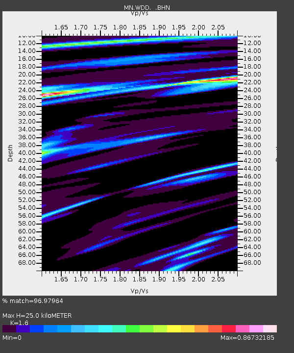
| Estimated Moho Depth: |
25.0 km |
| Estimated Crust Vp/Vs: |
1.60 |
| Assumed Crust Vp: |
4.05 km/s |
| Estimated Crust Vs: |
2.531 km/s |
| Estimated Crust Poisson's Ratio: |
0.18 |
|
| Radial Match: |
96.97964 % |
| Radial Bump: |
335 |
| Transverse Match: |
90.33297 % |
| Transverse Bump: |
400 |
| SOD ConfigId: |
2564 |
| Insert Time: |
2010-03-08 18:01:27.456 +0000 |
| GWidth: |
2.5 |
| Max Bumps: |
400 |
| Tol: |
0.001 |
|
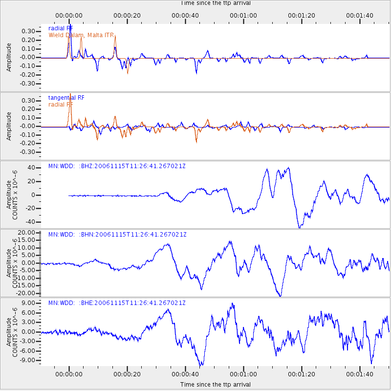
Signal To Noise
| Channel | StoN | STA | LTA |
| MN:WDD: :BHN:20061115T11:26:41.267021Z | 2.3244712 | 6.9837654E-7 | 3.0044532E-7 |
| MN:WDD: :BHE:20061115T11:26:41.267021Z | 0.96064895 | 3.2934122E-7 | 3.42832E-7 |
| MN:WDD: :BHZ:20061115T11:26:41.267021Z | 9.231166 | 2.7547433E-6 | 2.984177E-7 |
| Arrivals |
| Ps | 3.7 SECOND |
| PpPs | 16 SECOND |
| PsPs/PpSs | 20 SECOND |


