You are here: Home > Network List > MN - MEDNET Project Stations List
> Station WDD Wield Dalam, Malta > Earthquake Result Viewer
WDD Wield Dalam, Malta - Earthquake Result Viewer
| Earthquake location: |
Hindu Kush Region, Afghanistan |
| Earthquake latitude/longitude: |
36.3/70.9 |
| Earthquake time(UTC): |
2000/07/17 (199) 22:53:47 GMT |
| Earthquake Depth: |
141 km |
| Earthquake Magnitude: |
6.0 MB, 6.4 MW, 6.3 MW |
| Earthquake Catalog/Contributor: |
WHDF/NEIC |
|
| Network: |
MN MEDNET Project |
| Station: |
WDD Wield Dalam, Malta |
| Lat/Lon: |
35.87 N/14.52 E |
| Elevation: |
41 m |
|
| Distance: |
45.0 deg |
| Az: |
286.973 deg |
| Baz: |
72.071 deg |
| Ray Param: |
0.07102565 |
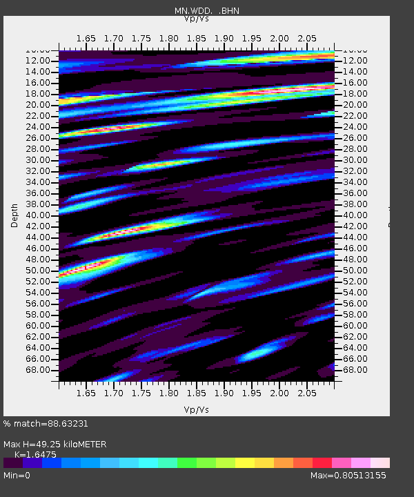
| Estimated Moho Depth: |
49.25 km |
| Estimated Crust Vp/Vs: |
1.65 |
| Assumed Crust Vp: |
4.05 km/s |
| Estimated Crust Vs: |
2.458 km/s |
| Estimated Crust Poisson's Ratio: |
0.21 |
|
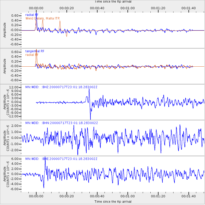
| Radial Match: |
88.63231 % |
| Radial Bump: |
389 |
| Transverse Match: |
69.996506 % |
| Transverse Bump: |
400 |
| SOD ConfigId: |
3744 |
| Insert Time: |
2010-03-08 18:01:57.550 +0000 |
| GWidth: |
2.5 |
| Max Bumps: |
400 |
| Tol: |
0.001 |
|
Signal To Noise
| Channel | StoN | STA | LTA |
| MN:WDD: :BHN:20000717T23:01:18.283002Z | 0.90614825 | 3.479129E-7 | 3.8394703E-7 |
| MN:WDD: :BHE:20000717T23:01:18.283002Z | 4.826959 | 1.3098366E-6 | 2.7135854E-7 |
| MN:WDD: :BHZ:20000717T23:01:18.283002Z | 10.929188 | 3.1690233E-6 | 2.8995964E-7 |
| Arrivals |
| Ps | 8.1 SECOND |
| PpPs | 31 SECOND |
| PsPs/PpSs | 39 SECOND |


