You are here: Home > Network List > MN - MEDNET Project Stations List
> Station WDD Wield Dalam, Malta > Earthquake Result Viewer
WDD Wield Dalam, Malta - Earthquake Result Viewer
| Earthquake location: |
Myanmar |
| Earthquake latitude/longitude: |
26.9/97.2 |
| Earthquake time(UTC): |
2000/06/07 (159) 21:46:55 GMT |
| Earthquake Depth: |
33 km |
| Earthquake Magnitude: |
6.3 MB, 6.5 MS, 6.4 MW, 6.4 MW |
| Earthquake Catalog/Contributor: |
WHDF/NEIC |
|
| Network: |
MN MEDNET Project |
| Station: |
WDD Wield Dalam, Malta |
| Lat/Lon: |
35.87 N/14.52 E |
| Elevation: |
41 m |
|
| Distance: |
69.3 deg |
| Az: |
300.513 deg |
| Baz: |
71.361 deg |
| Ray Param: |
0.0557144 |
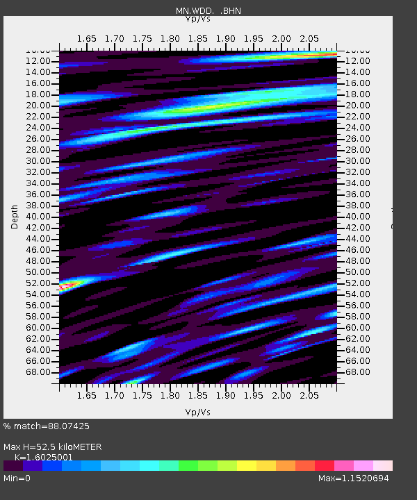
| Estimated Moho Depth: |
52.5 km |
| Estimated Crust Vp/Vs: |
1.60 |
| Assumed Crust Vp: |
4.05 km/s |
| Estimated Crust Vs: |
2.527 km/s |
| Estimated Crust Poisson's Ratio: |
0.18 |
|
| Radial Match: |
88.07425 % |
| Radial Bump: |
400 |
| Transverse Match: |
78.88112 % |
| Transverse Bump: |
400 |
| SOD ConfigId: |
3744 |
| Insert Time: |
2010-03-08 18:02:01.405 +0000 |
| GWidth: |
2.5 |
| Max Bumps: |
400 |
| Tol: |
0.001 |
|
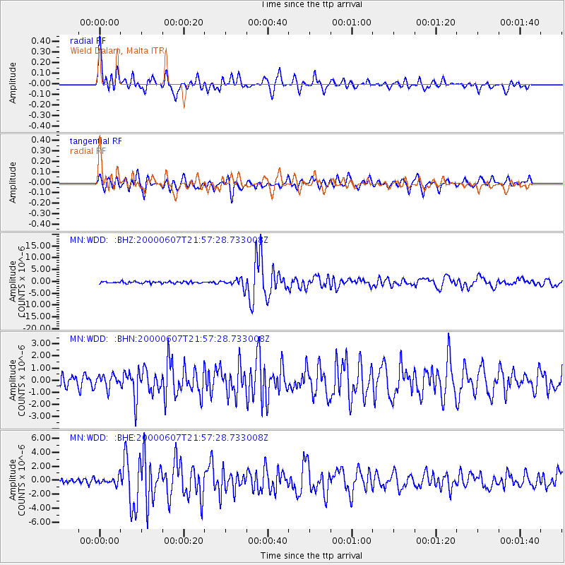
Signal To Noise
| Channel | StoN | STA | LTA |
| MN:WDD: :BHN:20000607T21:57:28.733008Z | 1.1619445 | 5.130518E-7 | 4.415459E-7 |
| MN:WDD: :BHE:20000607T21:57:28.733008Z | 1.0106846 | 5.228766E-7 | 5.1734895E-7 |
| MN:WDD: :BHZ:20000607T21:57:28.733008Z | 5.1476684 | 1.8937101E-6 | 3.6787725E-7 |
| Arrivals |
| Ps | 7.9 SECOND |
| PpPs | 33 SECOND |
| PsPs/PpSs | 41 SECOND |


