You are here: Home > Network List > MN - MEDNET Project Stations List
> Station WDD Wield Dalam, Malta > Earthquake Result Viewer
WDD Wield Dalam, Malta - Earthquake Result Viewer
| Earthquake location: |
Hindu Kush Region, Afghanistan |
| Earthquake latitude/longitude: |
36.0/70.7 |
| Earthquake time(UTC): |
2000/05/12 (133) 23:10:29 GMT |
| Earthquake Depth: |
108 km |
| Earthquake Magnitude: |
6.2 MB, 6.3 MW, 6.3 MW |
| Earthquake Catalog/Contributor: |
WHDF/NEIC |
|
| Network: |
MN MEDNET Project |
| Station: |
WDD Wield Dalam, Malta |
| Lat/Lon: |
35.87 N/14.52 E |
| Elevation: |
41 m |
|
| Distance: |
44.9 deg |
| Az: |
287.174 deg |
| Baz: |
72.577 deg |
| Ray Param: |
0.0712464 |
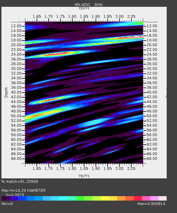
| Estimated Moho Depth: |
16.25 km |
| Estimated Crust Vp/Vs: |
2.09 |
| Assumed Crust Vp: |
4.05 km/s |
| Estimated Crust Vs: |
1.94 km/s |
| Estimated Crust Poisson's Ratio: |
0.35 |
|
| Radial Match: |
91.20908 % |
| Radial Bump: |
400 |
| Transverse Match: |
86.601006 % |
| Transverse Bump: |
400 |
| SOD ConfigId: |
3744 |
| Insert Time: |
2010-03-08 18:02:04.731 +0000 |
| GWidth: |
2.5 |
| Max Bumps: |
400 |
| Tol: |
0.001 |
|
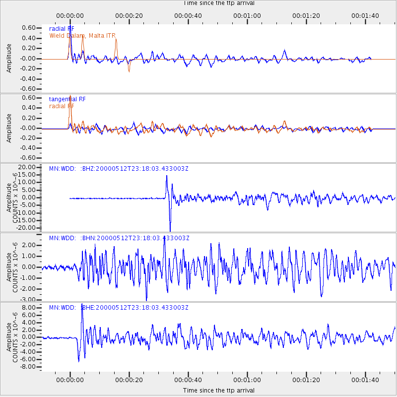
Signal To Noise
| Channel | StoN | STA | LTA |
| MN:WDD: :BHN:20000512T23:18:03.433003Z | 5.262039 | 5.357493E-7 | 1.01813995E-7 |
| MN:WDD: :BHE:20000512T23:18:03.433003Z | 24.523815 | 3.107433E-6 | 1.2671083E-7 |
| MN:WDD: :BHZ:20000512T23:18:03.433003Z | 58.51961 | 6.890042E-6 | 1.17739035E-7 |
| Arrivals |
| Ps | 4.5 SECOND |
| PpPs | 12 SECOND |
| PsPs/PpSs | 17 SECOND |


