You are here: Home > Network List > MN - MEDNET Project Stations List
> Station WDD Wield Dalam, Malta > Earthquake Result Viewer
WDD Wield Dalam, Malta - Earthquake Result Viewer
| Earthquake location: |
Iceland |
| Earthquake latitude/longitude: |
64.0/-20.5 |
| Earthquake time(UTC): |
2000/06/17 (169) 15:40:41 GMT |
| Earthquake Depth: |
10 km |
| Earthquake Magnitude: |
5.7 MB, 6.6 MS, 6.8 MW, 6.5 MW |
| Earthquake Catalog/Contributor: |
WHDF/NEIC |
|
| Network: |
MN MEDNET Project |
| Station: |
WDD Wield Dalam, Malta |
| Lat/Lon: |
35.87 N/14.52 E |
| Elevation: |
41 m |
|
| Distance: |
35.2 deg |
| Az: |
126.081 deg |
| Baz: |
333.955 deg |
| Ray Param: |
0.07734164 |
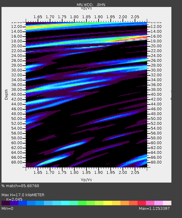
| Estimated Moho Depth: |
17.0 km |
| Estimated Crust Vp/Vs: |
2.05 |
| Assumed Crust Vp: |
4.05 km/s |
| Estimated Crust Vs: |
1.981 km/s |
| Estimated Crust Poisson's Ratio: |
0.34 |
|
| Radial Match: |
85.68768 % |
| Radial Bump: |
372 |
| Transverse Match: |
72.984985 % |
| Transverse Bump: |
400 |
| SOD ConfigId: |
3744 |
| Insert Time: |
2010-03-08 18:02:08.898 +0000 |
| GWidth: |
2.5 |
| Max Bumps: |
400 |
| Tol: |
0.001 |
|

Signal To Noise
| Channel | StoN | STA | LTA |
| MN:WDD: :BHN:20000617T15:47:05.283009Z | 1.9738472 | 1.0492108E-6 | 5.315563E-7 |
| MN:WDD: :BHE:20000617T15:47:05.283009Z | 1.4720579 | 5.7935284E-7 | 3.9356658E-7 |
| MN:WDD: :BHZ:20000617T15:47:05.283009Z | 5.3044114 | 1.8338505E-6 | 3.457218E-7 |
| Arrivals |
| Ps | 4.5 SECOND |
| PpPs | 12 SECOND |
| PsPs/PpSs | 17 SECOND |


