You are here: Home > Network List > CI - Caltech Regional Seismic Network Stations List
> Station LRL Laurel Mtn Radio Fac, Ridgecrest, CA, USA > Earthquake Result Viewer
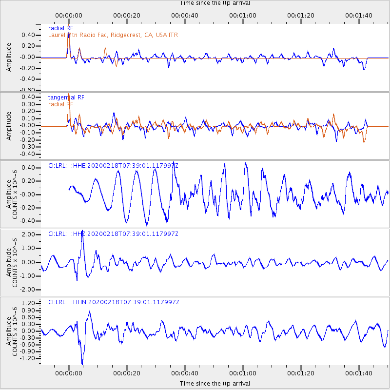
LRL Laurel Mtn Radio Fac, Ridgecrest, CA, USA - Earthquake Result Viewer
*The percent match for this event was below the threshold and hence no stack was calculated.
| Earthquake location: |
North Of Svalbard |
| Earthquake latitude/longitude: |
85.7/22.7 |
| Earthquake time(UTC): |
2020/02/18 (049) 07:29:39 GMT |
| Earthquake Depth: |
10 km |
| Earthquake Magnitude: |
5.2 Mww |
| Earthquake Catalog/Contributor: |
NEIC PDE/us |
|
| Network: |
CI Caltech Regional Seismic Network |
| Station: |
LRL Laurel Mtn Radio Fac, Ridgecrest, CA, USA |
| Lat/Lon: |
35.48 N/117.68 W |
| Elevation: |
1340 m |
|
| Distance: |
58.0 deg |
| Az: |
322.167 deg |
| Baz: |
3.222 deg |
| Ray Param: |
$rayparam |
*The percent match for this event was below the threshold and hence was not used in the summary stack. |
|
| Radial Match: |
64.16416 % |
| Radial Bump: |
400 |
| Transverse Match: |
71.71937 % |
| Transverse Bump: |
400 |
| SOD ConfigId: |
20831131 |
| Insert Time: |
2020-03-15 20:19:55.957 +0000 |
| GWidth: |
2.5 |
| Max Bumps: |
400 |
| Tol: |
0.001 |
|
Signal To Noise
| Channel | StoN | STA | LTA |
| CI:LRL: :HHZ:20200218T07:39:01.117997Z | 3.001875 | 8.1951316E-7 | 2.7300044E-7 |
| CI:LRL: :HHN:20200218T07:39:01.117997Z | 2.7685606 | 5.1318534E-7 | 1.8536178E-7 |
| CI:LRL: :HHE:20200218T07:39:01.117997Z | 1.4623302 | 2.8039594E-7 | 1.9174598E-7 |
| Arrivals |
| Ps | |
| PpPs | |
| PsPs/PpSs | |


