You are here: Home > Network List > MN - MEDNET Project Stations List
> Station WDD Wield Dalam, Malta > Earthquake Result Viewer
WDD Wield Dalam, Malta - Earthquake Result Viewer
| Earthquake location: |
Jan Mayen Island Region |
| Earthquake latitude/longitude: |
71.2/-8.3 |
| Earthquake time(UTC): |
2000/05/21 (142) 19:58:47 GMT |
| Earthquake Depth: |
10 km |
| Earthquake Magnitude: |
5.3 MB, 5.6 MS, 6.0 MW, 6.0 MW |
| Earthquake Catalog/Contributor: |
WHDF/NEIC |
|
| Network: |
MN MEDNET Project |
| Station: |
WDD Wield Dalam, Malta |
| Lat/Lon: |
35.87 N/14.52 E |
| Elevation: |
41 m |
|
| Distance: |
37.4 deg |
| Az: |
148.786 deg |
| Baz: |
348.056 deg |
| Ray Param: |
0.07617071 |
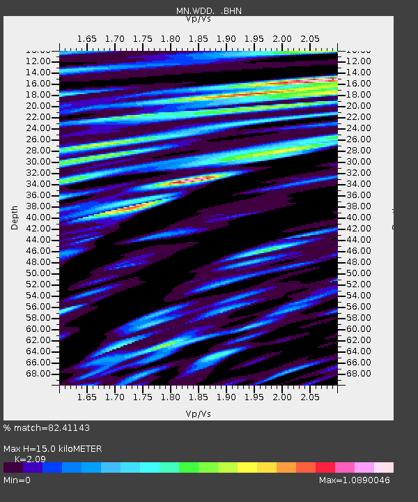
| Estimated Moho Depth: |
15.0 km |
| Estimated Crust Vp/Vs: |
2.09 |
| Assumed Crust Vp: |
4.05 km/s |
| Estimated Crust Vs: |
1.938 km/s |
| Estimated Crust Poisson's Ratio: |
0.35 |
|
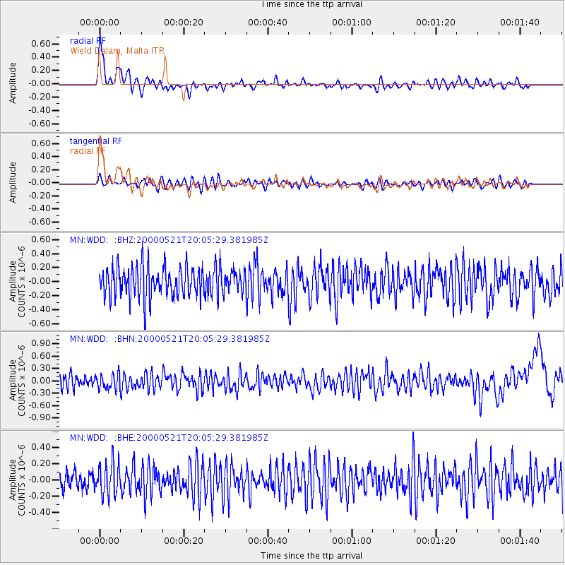
| Radial Match: |
82.41143 % |
| Radial Bump: |
400 |
| Transverse Match: |
55.130913 % |
| Transverse Bump: |
400 |
| SOD ConfigId: |
3744 |
| Insert Time: |
2010-03-08 18:02:10.050 +0000 |
| GWidth: |
2.5 |
| Max Bumps: |
400 |
| Tol: |
0.001 |
|
Signal To Noise
| Channel | StoN | STA | LTA |
| MN:WDD: :BHN:20000521T20:05:29.381985Z | 1.1213233 | 1.8333985E-7 | 1.635031E-7 |
| MN:WDD: :BHE:20000521T20:05:29.381985Z | 1.7565237 | 1.9834546E-7 | 1.1291932E-7 |
| MN:WDD: :BHZ:20000521T20:05:29.381985Z | 0.6008373 | 1.2979764E-7 | 2.1602793E-7 |
| Arrivals |
| Ps | 4.1 SECOND |
| PpPs | 11 SECOND |
| PsPs/PpSs | 15 SECOND |


