You are here: Home > Network List > MN - MEDNET Project Stations List
> Station WDD Wield Dalam, Malta > Earthquake Result Viewer
WDD Wield Dalam, Malta - Earthquake Result Viewer
| Earthquake location: |
Southern India |
| Earthquake latitude/longitude: |
23.4/70.2 |
| Earthquake time(UTC): |
2001/01/26 (026) 03:16:40 GMT |
| Earthquake Depth: |
16 km |
| Earthquake Magnitude: |
6.9 MB, 8.0 MS, 7.7 MW, 7.7 ME |
| Earthquake Catalog/Contributor: |
WHDF/NEIC |
|
| Network: |
MN MEDNET Project |
| Station: |
WDD Wield Dalam, Malta |
| Lat/Lon: |
35.87 N/14.52 E |
| Elevation: |
41 m |
|
| Distance: |
49.4 deg |
| Az: |
297.878 deg |
| Baz: |
88.557 deg |
| Ray Param: |
0.06871529 |
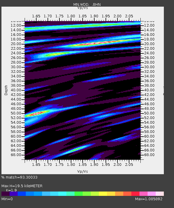
| Estimated Moho Depth: |
19.5 km |
| Estimated Crust Vp/Vs: |
1.90 |
| Assumed Crust Vp: |
4.05 km/s |
| Estimated Crust Vs: |
2.132 km/s |
| Estimated Crust Poisson's Ratio: |
0.31 |
|
| Radial Match: |
93.30033 % |
| Radial Bump: |
379 |
| Transverse Match: |
86.4577 % |
| Transverse Bump: |
400 |
| SOD ConfigId: |
3744 |
| Insert Time: |
2010-03-08 18:02:18.164 +0000 |
| GWidth: |
2.5 |
| Max Bumps: |
400 |
| Tol: |
0.001 |
|
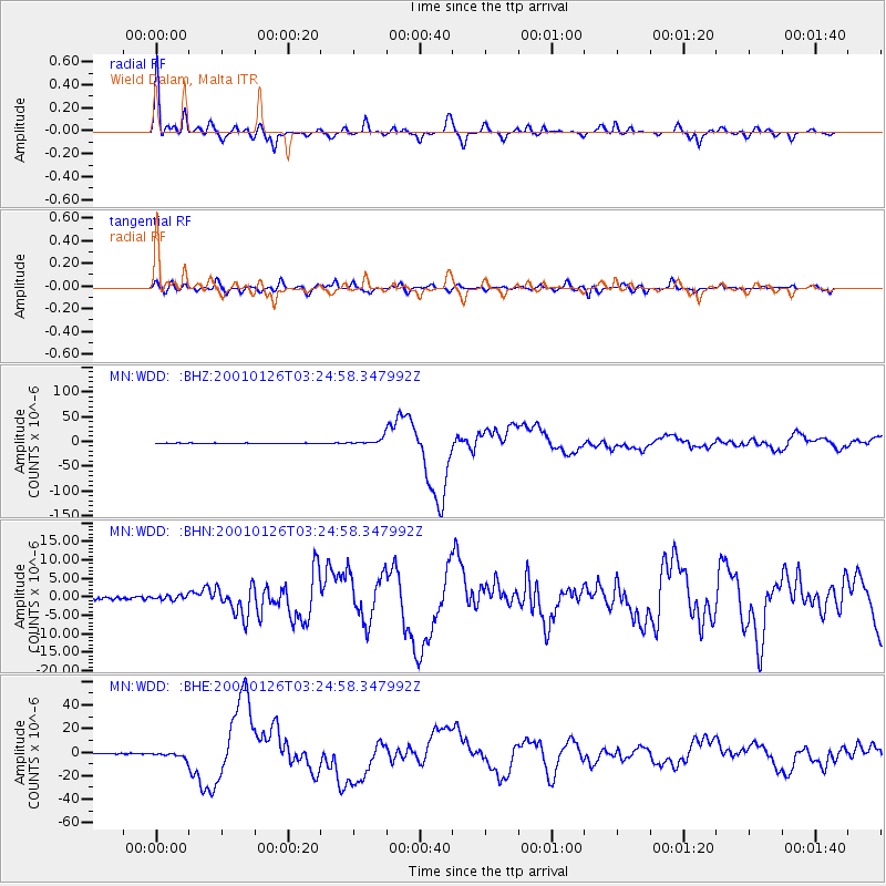
Signal To Noise
| Channel | StoN | STA | LTA |
| MN:WDD: :BHN:20010126T03:24:58.347992Z | 1.2299055 | 6.040373E-7 | 4.91125E-7 |
| MN:WDD: :BHE:20010126T03:24:58.347992Z | 6.635406 | 2.5082686E-6 | 3.7801283E-7 |
| MN:WDD: :BHZ:20010126T03:24:58.347992Z | 14.886628 | 6.3672956E-6 | 4.2771913E-7 |
| Arrivals |
| Ps | 4.4 SECOND |
| PpPs | 14 SECOND |
| PsPs/PpSs | 18 SECOND |


