You are here: Home > Network List > MN - MEDNET Project Stations List
> Station WDD Wield Dalam, Malta > Earthquake Result Viewer
WDD Wield Dalam, Malta - Earthquake Result Viewer
| Earthquake location: |
Hindu Kush Region, Afghanistan |
| Earthquake latitude/longitude: |
36.4/70.9 |
| Earthquake time(UTC): |
2001/02/25 (056) 02:21:59 GMT |
| Earthquake Depth: |
202 km |
| Earthquake Magnitude: |
5.8 MB, 6.3 MW, 6.1 MW |
| Earthquake Catalog/Contributor: |
WHDF/NEIC |
|
| Network: |
MN MEDNET Project |
| Station: |
WDD Wield Dalam, Malta |
| Lat/Lon: |
35.87 N/14.52 E |
| Elevation: |
41 m |
|
| Distance: |
44.9 deg |
| Az: |
286.823 deg |
| Baz: |
71.895 deg |
| Ray Param: |
0.0708137 |
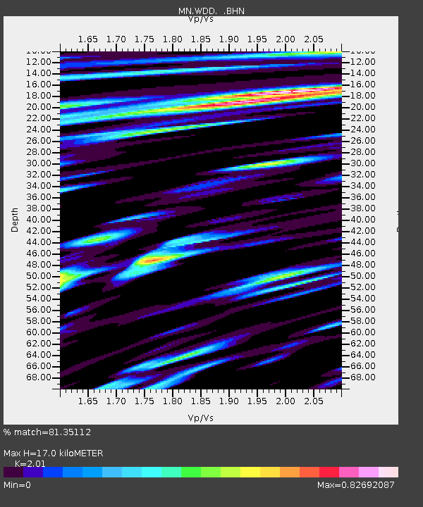
| Estimated Moho Depth: |
17.0 km |
| Estimated Crust Vp/Vs: |
2.01 |
| Assumed Crust Vp: |
4.05 km/s |
| Estimated Crust Vs: |
2.015 km/s |
| Estimated Crust Poisson's Ratio: |
0.34 |
|
| Radial Match: |
81.35112 % |
| Radial Bump: |
400 |
| Transverse Match: |
65.60693 % |
| Transverse Bump: |
400 |
| SOD ConfigId: |
3744 |
| Insert Time: |
2010-03-08 18:02:20.557 +0000 |
| GWidth: |
2.5 |
| Max Bumps: |
400 |
| Tol: |
0.001 |
|
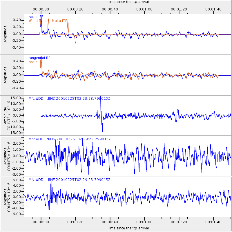
Signal To Noise
| Channel | StoN | STA | LTA |
| MN:WDD: :BHN:20010225T02:29:23.799015Z | 1.1057105 | 6.304597E-7 | 5.7018514E-7 |
| MN:WDD: :BHE:20010225T02:29:23.799015Z | 3.3176405 | 1.6125931E-6 | 4.8606626E-7 |
| MN:WDD: :BHZ:20010225T02:29:23.799015Z | 6.129326 | 4.0405826E-6 | 6.5922137E-7 |
| Arrivals |
| Ps | 4.3 SECOND |
| PpPs | 12 SECOND |
| PsPs/PpSs | 17 SECOND |


