You are here: Home > Network List > MN - MEDNET Project Stations List
> Station WDD Wield Dalam, Malta > Earthquake Result Viewer
WDD Wield Dalam, Malta - Earthquake Result Viewer
| Earthquake location: |
Near Coast Of Peru |
| Earthquake latitude/longitude: |
-16.3/-73.6 |
| Earthquake time(UTC): |
2001/06/23 (174) 20:33:14 GMT |
| Earthquake Depth: |
33 km |
| Earthquake Magnitude: |
6.7 MB, 8.2 MS, 8.4 MW, 7.8 ME |
| Earthquake Catalog/Contributor: |
WHDF/NEIC |
|
| Network: |
MN MEDNET Project |
| Station: |
WDD Wield Dalam, Malta |
| Lat/Lon: |
35.87 N/14.52 E |
| Elevation: |
41 m |
|
| Distance: |
97.9 deg |
| Az: |
55.044 deg |
| Baz: |
255.737 deg |
| Ray Param: |
0.040056866 |
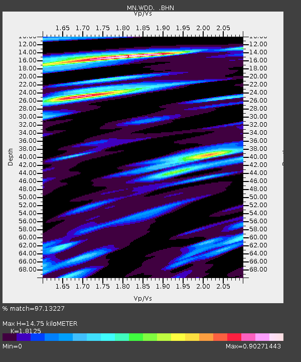
| Estimated Moho Depth: |
14.75 km |
| Estimated Crust Vp/Vs: |
1.81 |
| Assumed Crust Vp: |
4.05 km/s |
| Estimated Crust Vs: |
2.235 km/s |
| Estimated Crust Poisson's Ratio: |
0.28 |
|
| Radial Match: |
97.13227 % |
| Radial Bump: |
397 |
| Transverse Match: |
84.60122 % |
| Transverse Bump: |
400 |
| SOD ConfigId: |
4714 |
| Insert Time: |
2010-03-08 18:02:21.806 +0000 |
| GWidth: |
2.5 |
| Max Bumps: |
400 |
| Tol: |
0.001 |
|
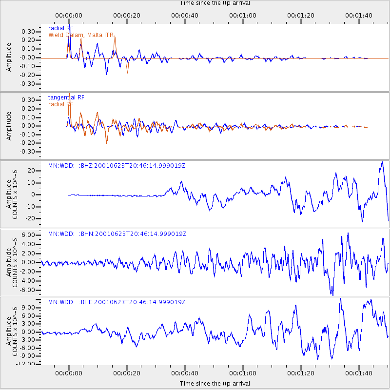
Signal To Noise
| Channel | StoN | STA | LTA |
| MN:WDD: :BHN:20010623T20:46:14.999019Z | 0.8327467 | 1.9836658E-7 | 2.3820759E-7 |
| MN:WDD: :BHE:20010623T20:46:14.999019Z | 2.2714922 | 5.224216E-7 | 2.2999048E-7 |
| MN:WDD: :BHZ:20010623T20:46:14.999019Z | 6.0677414 | 1.9411698E-6 | 3.1991635E-7 |
| Arrivals |
| Ps | 3.0 SECOND |
| PpPs | 10 SECOND |
| PsPs/PpSs | 13 SECOND |


