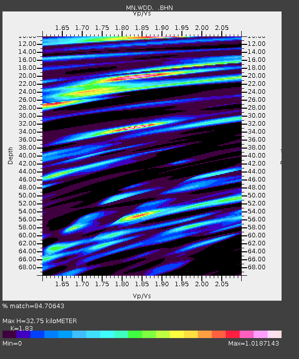
WDD Wield Dalam, Malta - Earthquake Result Viewer
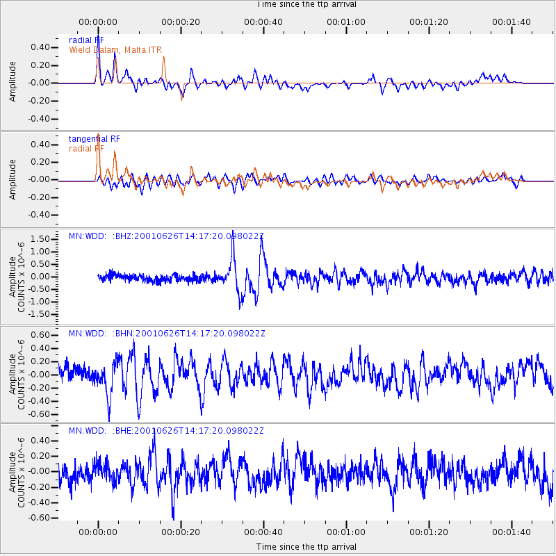
Earthquake location: Southern Yukon Territory, Canada
Earthquake latitude/longitude: 61.3/-140.1
Earthquake time(UTC): 2001/06/26 (177) 14:05:37 GMT
Earthquake Depth: 10 km
Earthquake Magnitude: 5.8 MB, 5.4 MS, 6.0 ML, 5.8 MW
Earthquake Catalog/Contributor: WHDF/NEIC
Network: MN MEDNET Project
Station: WDD Wield Dalam, Malta
Lat/Lon: 35.87 N/14.52 E
Elevation: 41 m
Distance: 80.9 deg
Az: 20.664 deg
Baz: 347.91 deg
Ray Param: 0.04793167
Estimated Moho Depth: 32.75 km
Estimated Crust Vp/Vs: 1.83
Assumed Crust Vp: 4.05 km/s
Estimated Crust Vs: 2.213 km/s
Estimated Crust Poisson's Ratio: 0.29
Radial Match: 84.70643 %
Radial Bump: 400
Transverse Match: 68.35079 %
Transverse Bump: 400
SOD ConfigId: 4714
Insert Time: 2010-03-08 18:02:23.559 +0000
GWidth: 2.5
Max Bumps: 400
Tol: 0.001

Signal To Noise

ChannelStoNSTALTA
MN:WDD: :BHN:20010626T14:17:20.098022Z2.487852.5364935E-71.01955244E-7
MN:WDD: :BHE:20010626T14:17:20.098022Z1.06282571.1484255E-71.08053975E-7
MN:WDD: :BHZ:20010626T14:17:20.098022Z5.52013166.836256E-71.2384227E-7
Arrivals
Ps6.8 SECOND
PpPs23 SECOND
PsPs/PpSs29 SECOND