You are here: Home > Network List > MN - MEDNET Project Stations List
> Station WDD Wield Dalam, Malta > Earthquake Result Viewer
WDD Wield Dalam, Malta - Earthquake Result Viewer
| Earthquake location: |
Near Coast Of Peru |
| Earthquake latitude/longitude: |
-17.5/-72.1 |
| Earthquake time(UTC): |
2001/07/07 (188) 09:38:43 GMT |
| Earthquake Depth: |
33 km |
| Earthquake Magnitude: |
6.6 MB, 7.3 MS, 7.6 MW, 7.5 ME |
| Earthquake Catalog/Contributor: |
WHDF/NEIC |
|
| Network: |
MN MEDNET Project |
| Station: |
WDD Wield Dalam, Malta |
| Lat/Lon: |
35.87 N/14.52 E |
| Elevation: |
41 m |
|
| Distance: |
97.4 deg |
| Az: |
54.847 deg |
| Baz: |
253.82 deg |
| Ray Param: |
0.04020953 |
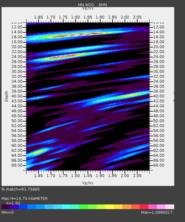
| Estimated Moho Depth: |
14.75 km |
| Estimated Crust Vp/Vs: |
1.82 |
| Assumed Crust Vp: |
4.05 km/s |
| Estimated Crust Vs: |
2.225 km/s |
| Estimated Crust Poisson's Ratio: |
0.28 |
|
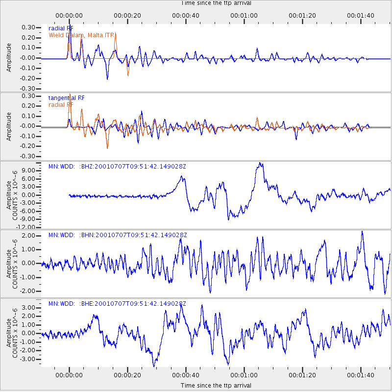
| Radial Match: |
93.75665 % |
| Radial Bump: |
400 |
| Transverse Match: |
85.775734 % |
| Transverse Bump: |
400 |
| SOD ConfigId: |
4714 |
| Insert Time: |
2010-03-08 18:02:26.040 +0000 |
| GWidth: |
2.5 |
| Max Bumps: |
400 |
| Tol: |
0.001 |
|
Signal To Noise
| Channel | StoN | STA | LTA |
| MN:WDD: :BHN:20010707T09:51:42.149028Z | 1.1577876 | 2.9036525E-7 | 2.507932E-7 |
| MN:WDD: :BHE:20010707T09:51:42.149028Z | 1.0284793 | 2.645282E-7 | 2.5720325E-7 |
| MN:WDD: :BHZ:20010707T09:51:42.149028Z | 2.8617969 | 6.24425E-7 | 2.1819334E-7 |
| Arrivals |
| Ps | 3.0 SECOND |
| PpPs | 10 SECOND |
| PsPs/PpSs | 13 SECOND |


