You are here: Home > Network List > MN - MEDNET Project Stations List
> Station WDD Wield Dalam, Malta > Earthquake Result Viewer
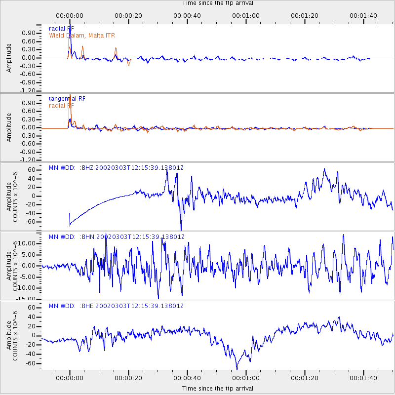
WDD Wield Dalam, Malta - Earthquake Result Viewer

| Earthquake location: |
Hindu Kush Region, Afghanistan |
| Earthquake latitude/longitude: |
36.5/70.5 |
| Earthquake time(UTC): |
2002/03/03 (062) 12:08:19 GMT |
| Earthquake Depth: |
226 km |
| Earthquake Magnitude: |
6.6 MB, 7.4 MW, 7.3 MW |
| Earthquake Catalog/Contributor: |
WHDF/NEIC |
|
| Network: |
MN MEDNET Project |
| Station: |
WDD Wield Dalam, Malta |
| Lat/Lon: |
35.87 N/14.52 E |
| Elevation: |
41 m |
|
| Distance: |
44.6 deg |
| Az: |
286.605 deg |
| Baz: |
71.92 deg |
| Ray Param: |
0.07091426 |
| Estimated Moho Depth: |
23.25 km |
| Estimated Crust Vp/Vs: |
1.78 |
| Assumed Crust Vp: |
4.05 km/s |
| Estimated Crust Vs: |
2.272 km/s |
| Estimated Crust Poisson's Ratio: |
0.27 |
|
| Radial Match: |
96.13387 % |
| Radial Bump: |
227 |
| Transverse Match: |
91.12587 % |
| Transverse Bump: |
388 |
| SOD ConfigId: |
20082 |
| Insert Time: |
2010-03-08 18:02:32.422 +0000 |
| GWidth: |
2.5 |
| Max Bumps: |
400 |
| Tol: |
0.001 |
|
Signal To Noise
| Channel | StoN | STA | LTA |
| MN:WDD: :BHN:20020303T12:15:39.13801Z | 5.3982005 | 1.7415815E-6 | 3.226226E-7 |
| MN:WDD: :BHE:20020303T12:15:39.13801Z | 1.2280947 | 3.6379097E-5 | 2.962239E-5 |
| MN:WDD: :BHZ:20020303T12:15:39.13801Z | 1.6265656 | 3.5075525E-5 | 2.1564163E-5 |
| Arrivals |
| Ps | 4.6 SECOND |
| PpPs | 16 SECOND |
| PsPs/PpSs | 20 SECOND |


