You are here: Home > Network List > MN - MEDNET Project Stations List
> Station WDD Wield Dalam, Malta > Earthquake Result Viewer
WDD Wield Dalam, Malta - Earthquake Result Viewer
| Earthquake location: |
Near East Coast Of Kamchatka |
| Earthquake latitude/longitude: |
52.0/157.3 |
| Earthquake time(UTC): |
2002/10/16 (289) 10:12:21 GMT |
| Earthquake Depth: |
102 km |
| Earthquake Magnitude: |
6.1 MB, 6.2 MW, 6.2 MW |
| Earthquake Catalog/Contributor: |
WHDF/NEIC |
|
| Network: |
MN MEDNET Project |
| Station: |
WDD Wield Dalam, Malta |
| Lat/Lon: |
35.87 N/14.52 E |
| Elevation: |
41 m |
|
| Distance: |
86.7 deg |
| Az: |
330.534 deg |
| Baz: |
22.012 deg |
| Ray Param: |
0.04365296 |
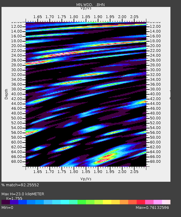
| Estimated Moho Depth: |
23.0 km |
| Estimated Crust Vp/Vs: |
1.75 |
| Assumed Crust Vp: |
4.05 km/s |
| Estimated Crust Vs: |
2.308 km/s |
| Estimated Crust Poisson's Ratio: |
0.26 |
|
| Radial Match: |
92.25552 % |
| Radial Bump: |
400 |
| Transverse Match: |
91.51396 % |
| Transverse Bump: |
400 |
| SOD ConfigId: |
4714 |
| Insert Time: |
2010-03-08 18:02:35.294 +0000 |
| GWidth: |
2.5 |
| Max Bumps: |
400 |
| Tol: |
0.001 |
|
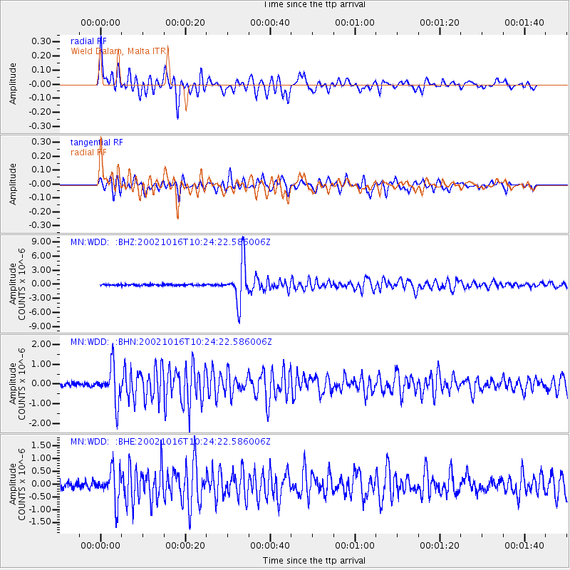
Signal To Noise
| Channel | StoN | STA | LTA |
| MN:WDD: :BHN:20021016T10:24:22.586006Z | 9.790262 | 9.3042524E-7 | 9.503578E-8 |
| MN:WDD: :BHE:20021016T10:24:22.586006Z | 5.5601287 | 6.2156323E-7 | 1.1178937E-7 |
| MN:WDD: :BHZ:20021016T10:24:22.586006Z | 33.84928 | 4.3840764E-6 | 1.2951757E-7 |
| Arrivals |
| Ps | 4.3 SECOND |
| PpPs | 16 SECOND |
| PsPs/PpSs | 20 SECOND |


