You are here: Home > Network List > MN - MEDNET Project Stations List
> Station WDD Wield Dalam, Malta > Earthquake Result Viewer
WDD Wield Dalam, Malta - Earthquake Result Viewer
| Earthquake location: |
Lake Tanganyika Region |
| Earthquake latitude/longitude: |
-1.9/29.0 |
| Earthquake time(UTC): |
2002/10/24 (297) 06:08:37 GMT |
| Earthquake Depth: |
11 km |
| Earthquake Magnitude: |
5.9 MB, 6.3 MS, 6.2 MW, 6.1 MW |
| Earthquake Catalog/Contributor: |
WHDF/NEIC |
|
| Network: |
MN MEDNET Project |
| Station: |
WDD Wield Dalam, Malta |
| Lat/Lon: |
35.87 N/14.52 E |
| Elevation: |
41 m |
|
| Distance: |
39.9 deg |
| Az: |
341.547 deg |
| Baz: |
157.078 deg |
| Ray Param: |
0.074698605 |
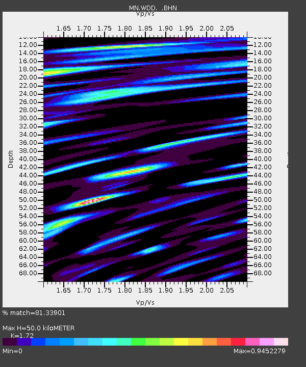
| Estimated Moho Depth: |
50.0 km |
| Estimated Crust Vp/Vs: |
1.72 |
| Assumed Crust Vp: |
4.05 km/s |
| Estimated Crust Vs: |
2.355 km/s |
| Estimated Crust Poisson's Ratio: |
0.24 |
|
| Radial Match: |
81.33901 % |
| Radial Bump: |
400 |
| Transverse Match: |
63.733566 % |
| Transverse Bump: |
400 |
| SOD ConfigId: |
4714 |
| Insert Time: |
2010-03-08 18:02:36.555 +0000 |
| GWidth: |
2.5 |
| Max Bumps: |
400 |
| Tol: |
0.001 |
|

Signal To Noise
| Channel | StoN | STA | LTA |
| MN:WDD: :BHN:20021024T06:15:41.137013Z | 1.5324814 | 6.0317836E-7 | 3.9359585E-7 |
| MN:WDD: :BHE:20021024T06:15:41.137013Z | 0.79098606 | 2.1424806E-7 | 2.70862E-7 |
| MN:WDD: :BHZ:20021024T06:15:41.137013Z | 3.1612573 | 1.0529347E-6 | 3.3307467E-7 |
| Arrivals |
| Ps | 9.1 SECOND |
| PpPs | 33 SECOND |
| PsPs/PpSs | 42 SECOND |


