You are here: Home > Network List > MN - MEDNET Project Stations List
> Station WDD Wield Dalam, Malta > Earthquake Result Viewer
WDD Wield Dalam, Malta - Earthquake Result Viewer
| Earthquake location: |
Kuril Islands |
| Earthquake latitude/longitude: |
46.0/151.5 |
| Earthquake time(UTC): |
2009/04/07 (097) 04:23:33 GMT |
| Earthquake Depth: |
31 km |
| Earthquake Magnitude: |
6.5 MB, 6.8 MS, 6.9 MW, 6.9 MW |
| Earthquake Catalog/Contributor: |
WHDF/NEIC |
|
| Network: |
MN MEDNET Project |
| Station: |
WDD Wield Dalam, Malta |
| Lat/Lon: |
35.87 N/14.52 E |
| Elevation: |
41 m |
|
| Distance: |
89.7 deg |
| Az: |
326.379 deg |
| Baz: |
28.344 deg |
| Ray Param: |
0.041720223 |
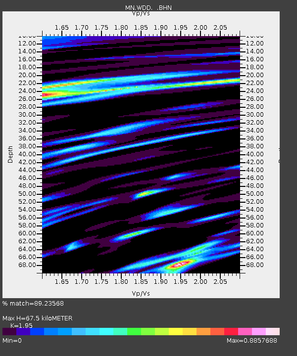
| Estimated Moho Depth: |
67.5 km |
| Estimated Crust Vp/Vs: |
1.95 |
| Assumed Crust Vp: |
4.05 km/s |
| Estimated Crust Vs: |
2.077 km/s |
| Estimated Crust Poisson's Ratio: |
0.32 |
|
| Radial Match: |
89.23568 % |
| Radial Bump: |
400 |
| Transverse Match: |
75.98222 % |
| Transverse Bump: |
400 |
| SOD ConfigId: |
2658 |
| Insert Time: |
2010-03-08 18:02:37.899 +0000 |
| GWidth: |
2.5 |
| Max Bumps: |
400 |
| Tol: |
0.001 |
|
Signal To Noise
| Channel | StoN | STA | LTA |
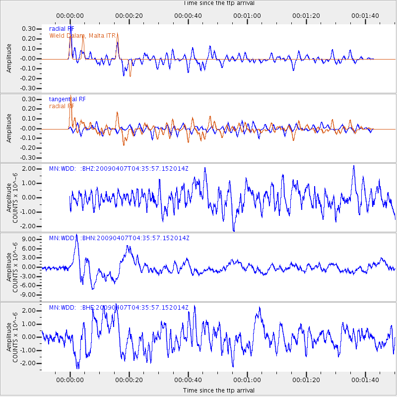
| MN:WDD: :BHN:20090407T04:35:57.152014Z | 14.6191435 | 4.707122E-6 | 3.2198346E-7 |
| MN:WDD: :BHE:20090407T04:35:57.152014Z | 4.1259055 | 1.178258E-6 | 2.8557562E-7 |
| MN:WDD: :BHZ:20090407T04:35:57.152014Z | 2.068536 | 7.6927915E-7 | 3.7189545E-7 |
| Arrivals |
| Ps | 16 SECOND |
| PpPs | 49 SECOND |
| PsPs/PpSs | 65 SECOND |


