You are here: Home > Network List > MN - MEDNET Project Stations List
> Station WDD Wield Dalam, Malta > Earthquake Result Viewer
WDD Wield Dalam, Malta - Earthquake Result Viewer
| Earthquake location: |
Caribbean Sea |
| Earthquake latitude/longitude: |
19.0/-81.4 |
| Earthquake time(UTC): |
2004/12/14 (349) 23:20:13 GMT |
| Earthquake Depth: |
10 km |
| Earthquake Magnitude: |
6.2 MB, 6.7 MS, 6.8 MW, 6.8 MW |
| Earthquake Catalog/Contributor: |
WHDF/NEIC |
|
| Network: |
MN MEDNET Project |
| Station: |
WDD Wield Dalam, Malta |
| Lat/Lon: |
35.87 N/14.52 E |
| Elevation: |
41 m |
|
| Distance: |
83.7 deg |
| Az: |
54.363 deg |
| Baz: |
288.739 deg |
| Ray Param: |
0.045968328 |
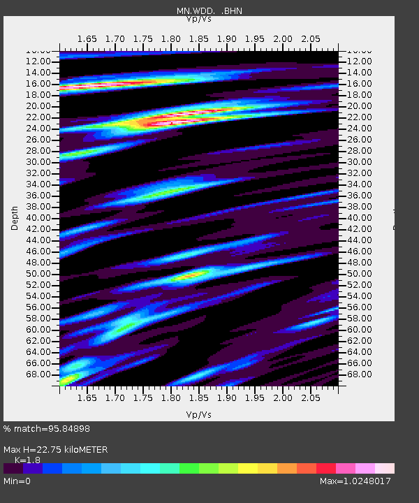
| Estimated Moho Depth: |
22.75 km |
| Estimated Crust Vp/Vs: |
1.80 |
| Assumed Crust Vp: |
4.05 km/s |
| Estimated Crust Vs: |
2.25 km/s |
| Estimated Crust Poisson's Ratio: |
0.28 |
|
| Radial Match: |
95.84898 % |
| Radial Bump: |
388 |
| Transverse Match: |
86.9643 % |
| Transverse Bump: |
400 |
| SOD ConfigId: |
2459 |
| Insert Time: |
2010-03-08 18:02:39.240 +0000 |
| GWidth: |
2.5 |
| Max Bumps: |
400 |
| Tol: |
0.001 |
|
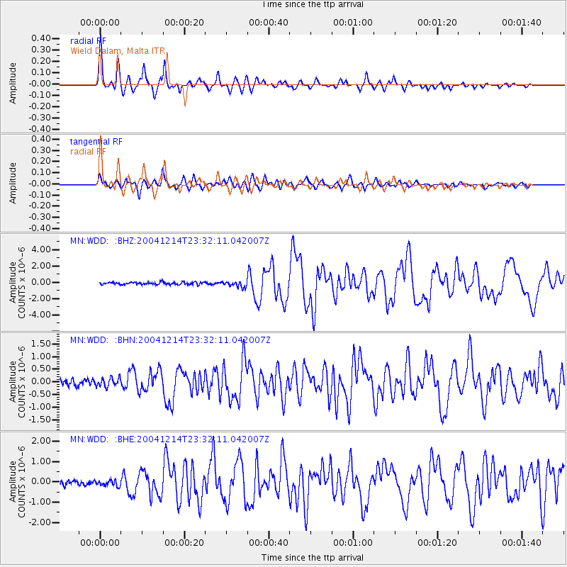
Signal To Noise
| Channel | StoN | STA | LTA |
| MN:WDD: :BHN:20041214T23:32:11.042007Z | 1.4787004 | 1.6841103E-7 | 1.1389125E-7 |
| MN:WDD: :BHE:20041214T23:32:11.042007Z | 1.0553187 | 1.3490501E-7 | 1.2783343E-7 |
| MN:WDD: :BHZ:20041214T23:32:11.042007Z | 2.4797864 | 3.6672913E-7 | 1.4788739E-7 |
| Arrivals |
| Ps | 4.5 SECOND |
| PpPs | 16 SECOND |
| PsPs/PpSs | 20 SECOND |


