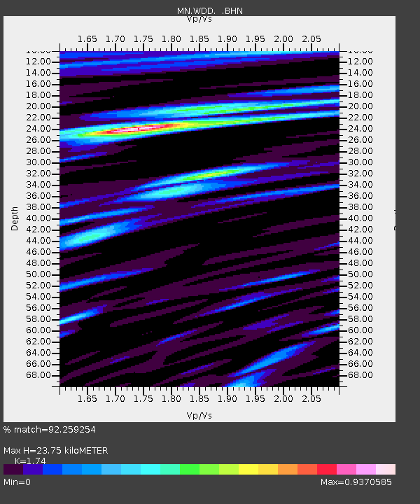
WDD Wield Dalam, Malta - Earthquake Result Viewer
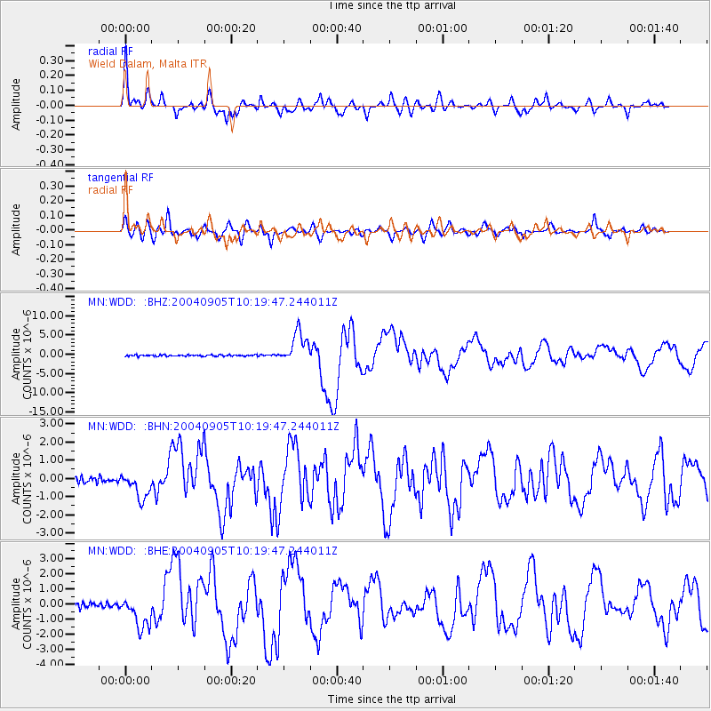
Earthquake location: Near S. Coast Of Western Honshu
Earthquake latitude/longitude: 33.1/136.6
Earthquake time(UTC): 2004/09/05 (249) 10:07:07 GMT
Earthquake Depth: 14 km
Earthquake Magnitude: 6.7 MB, 7.0 MS, 7.2 MW, 7.0 MW
Earthquake Catalog/Contributor: WHDF/NEIC
Network: MN MEDNET Project
Station: WDD Wield Dalam, Malta
Lat/Lon: 35.87 N/14.52 E
Elevation: 41 m
Distance: 92.6 deg
Az: 316.463 deg
Baz: 45.405 deg
Ray Param: 0.041422244
Estimated Moho Depth: 23.75 km
Estimated Crust Vp/Vs: 1.74
Assumed Crust Vp: 4.05 km/s
Estimated Crust Vs: 2.328 km/s
Estimated Crust Poisson's Ratio: 0.25
Radial Match: 92.259254 %
Radial Bump: 400
Transverse Match: 79.16823 %
Transverse Bump: 400
SOD ConfigId: 2459
Insert Time: 2010-03-08 18:02:43.849 +0000
GWidth: 2.5
Max Bumps: 400
Tol: 0.001

Signal To Noise

ChannelStoNSTALTA
MN:WDD: :BHN:20040905T10:19:47.244011Z4.137637.407033E-71.7901633E-7
MN:WDD: :BHE:20040905T10:19:47.244011Z5.5909141.0923719E-61.9538342E-7
MN:WDD: :BHZ:20040905T10:19:47.244011Z23.353814.0957293E-61.7537735E-7
Arrivals
Ps4.4 SECOND
PpPs16 SECOND
PsPs/PpSs20 SECOND