You are here: Home > Network List > GS - US Geological Survey Networks Stations List
> Station ASA5 ASA5 > Earthquake Result Viewer
ASA5 ASA5 - Earthquake Result Viewer
| Earthquake location: |
North Of Svalbard |
| Earthquake latitude/longitude: |
85.7/22.7 |
| Earthquake time(UTC): |
2020/02/18 (049) 07:29:39 GMT |
| Earthquake Depth: |
10 km |
| Earthquake Magnitude: |
5.2 Mww |
| Earthquake Catalog/Contributor: |
NEIC PDE/us |
|
| Network: |
GS US Geological Survey Networks |
| Station: |
ASA5 ASA5 |
| Lat/Lon: |
34.94 N/106.46 W |
| Elevation: |
1835 m |
|
| Distance: |
58.0 deg |
| Az: |
311.317 deg |
| Baz: |
3.92 deg |
| Ray Param: |
0.063127525 |
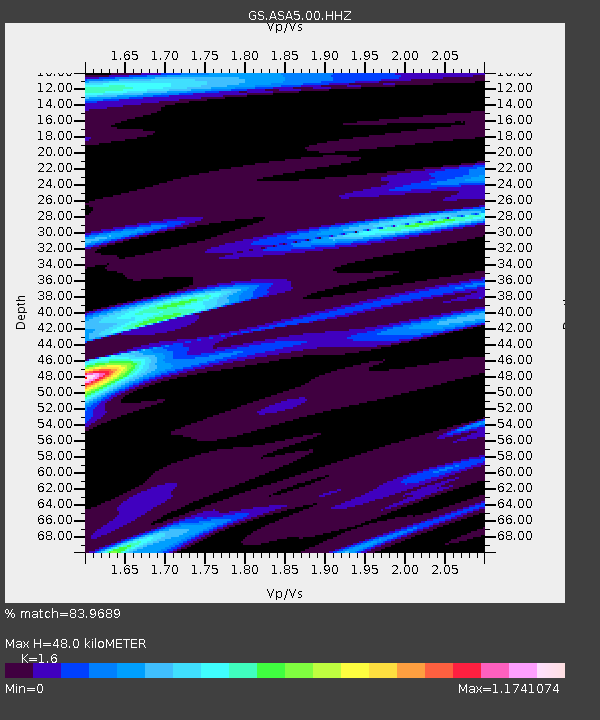
| Estimated Moho Depth: |
48.0 km |
| Estimated Crust Vp/Vs: |
1.60 |
| Assumed Crust Vp: |
6.502 km/s |
| Estimated Crust Vs: |
4.063 km/s |
| Estimated Crust Poisson's Ratio: |
0.18 |
|
| Radial Match: |
83.9689 % |
| Radial Bump: |
400 |
| Transverse Match: |
57.38715 % |
| Transverse Bump: |
370 |
| SOD ConfigId: |
20831131 |
| Insert Time: |
2020-03-15 21:22:55.321 +0000 |
| GWidth: |
2.5 |
| Max Bumps: |
400 |
| Tol: |
0.001 |
|

Signal To Noise
| Channel | StoN | STA | LTA |
| GS:ASA5:00:HHZ:20200218T07:39:00.839005Z | 6.5122027 | 7.386016E-7 | 1.1341809E-7 |
| GS:ASA5:00:HH1:20200218T07:39:00.839005Z | 3.7907038 | 4.0980996E-7 | 1.08109205E-7 |
| GS:ASA5:00:HH2:20200218T07:39:00.839005Z | 1.6172351 | 1.758045E-7 | 1.08706836E-7 |
| Arrivals |
| Ps | 4.7 SECOND |
| PpPs | 18 SECOND |
| PsPs/PpSs | 23 SECOND |


