You are here: Home > Network List > AG - Arkansas Seismic Network Stations List
> Station LCAR Lake Charles,AR > Earthquake Result Viewer
LCAR Lake Charles,AR - Earthquake Result Viewer
| Earthquake location: |
Southeastern Alaska |
| Earthquake latitude/longitude: |
59.9/-136.6 |
| Earthquake time(UTC): |
2017/05/01 (121) 12:31:53 GMT |
| Earthquake Depth: |
0.1 km |
| Earthquake Magnitude: |
6.5 Ml |
| Earthquake Catalog/Contributor: |
NEIC PDE/ak |
|
| Network: |
AG Arkansas Seismic Network |
| Station: |
LCAR Lake Charles,AR |
| Lat/Lon: |
36.07 N/91.15 W |
| Elevation: |
103 m |
|
| Distance: |
37.5 deg |
| Az: |
108.702 deg |
| Baz: |
323.852 deg |
| Ray Param: |
0.0761119 |
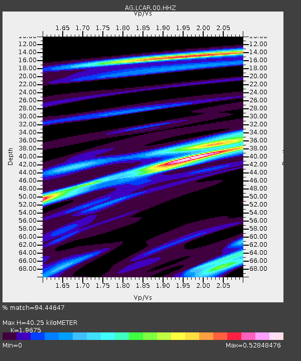
| Estimated Moho Depth: |
40.25 km |
| Estimated Crust Vp/Vs: |
1.97 |
| Assumed Crust Vp: |
6.53 km/s |
| Estimated Crust Vs: |
3.319 km/s |
| Estimated Crust Poisson's Ratio: |
0.33 |
|
| Radial Match: |
94.44647 % |
| Radial Bump: |
162 |
| Transverse Match: |
73.17742 % |
| Transverse Bump: |
385 |
| SOD ConfigId: |
2028011 |
| Insert Time: |
2017-05-15 12:32:23.979 +0000 |
| GWidth: |
2.5 |
| Max Bumps: |
400 |
| Tol: |
0.001 |
|
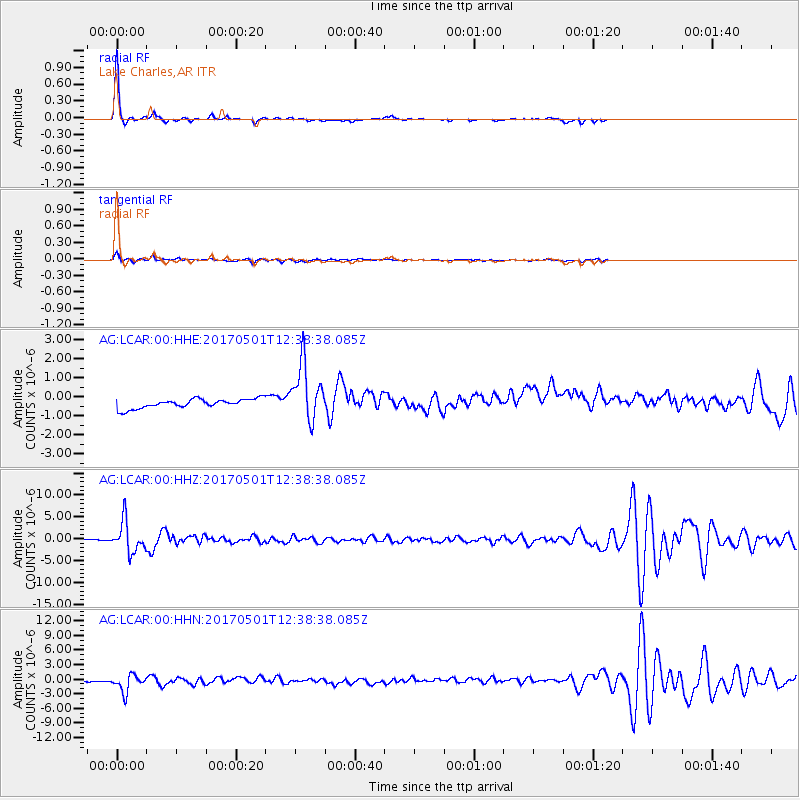
Signal To Noise
| Channel | StoN | STA | LTA |
| AG:LCAR:00:HHZ:20170501T12:38:38.085Z | 41.742622 | 3.5083713E-6 | 8.404769E-8 |
| AG:LCAR:00:HHN:20170501T12:38:38.085Z | 8.834201 | 1.836922E-6 | 2.0793301E-7 |
| AG:LCAR:00:HHE:20170501T12:38:38.085Z | 6.1478415 | 1.49441E-6 | 2.4307883E-7 |
| Arrivals |
| Ps | 6.4 SECOND |
| PpPs | 17 SECOND |
| PsPs/PpSs | 23 SECOND |


