You are here: Home > Network List > IW - Intermountain West Stations List
> Station FLWY Flagg Ranch, Wyoming, USA > Earthquake Result Viewer
FLWY Flagg Ranch, Wyoming, USA - Earthquake Result Viewer
| Earthquake location: |
North Of Svalbard |
| Earthquake latitude/longitude: |
85.7/22.7 |
| Earthquake time(UTC): |
2020/02/18 (049) 07:29:39 GMT |
| Earthquake Depth: |
10 km |
| Earthquake Magnitude: |
5.2 Mww |
| Earthquake Catalog/Contributor: |
NEIC PDE/us |
|
| Network: |
IW Intermountain West |
| Station: |
FLWY Flagg Ranch, Wyoming, USA |
| Lat/Lon: |
44.08 N/110.70 W |
| Elevation: |
2078 m |
|
| Distance: |
49.1 deg |
| Az: |
316.178 deg |
| Baz: |
4.12 deg |
| Ray Param: |
0.06889992 |
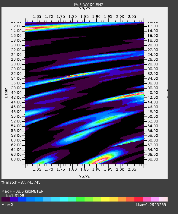
| Estimated Moho Depth: |
68.5 km |
| Estimated Crust Vp/Vs: |
1.91 |
| Assumed Crust Vp: |
6.35 km/s |
| Estimated Crust Vs: |
3.32 km/s |
| Estimated Crust Poisson's Ratio: |
0.31 |
|
| Radial Match: |
87.741745 % |
| Radial Bump: |
390 |
| Transverse Match: |
86.94547 % |
| Transverse Bump: |
395 |
| SOD ConfigId: |
20831131 |
| Insert Time: |
2020-03-15 21:37:17.319 +0000 |
| GWidth: |
2.5 |
| Max Bumps: |
400 |
| Tol: |
0.001 |
|

Signal To Noise
| Channel | StoN | STA | LTA |
| IW:FLWY:00:BHZ:20200218T07:37:55.870011Z | 14.071504 | 1.4715355E-6 | 1.0457557E-7 |
| IW:FLWY:00:BH1:20200218T07:37:55.870011Z | 3.2896864 | 7.394417E-7 | 2.2477575E-7 |
| IW:FLWY:00:BH2:20200218T07:37:55.870011Z | 0.8679064 | 2.1847597E-9 | 2.5172757E-9 |
| Arrivals |
| Ps | 10 SECOND |
| PpPs | 30 SECOND |
| PsPs/PpSs | 40 SECOND |


