You are here: Home > Network List > MN - MEDNET Project Stations List
> Station WDD Wield Dalam, Malta > Earthquake Result Viewer
WDD Wield Dalam, Malta - Earthquake Result Viewer
| Earthquake location: |
Sea Of Okhotsk |
| Earthquake latitude/longitude: |
53.9/152.9 |
| Earthquake time(UTC): |
2008/07/05 (187) 02:12:04 GMT |
| Earthquake Depth: |
633 km |
| Earthquake Magnitude: |
6.8 MB, 7.7 MW, 7.7 MW |
| Earthquake Catalog/Contributor: |
WHDF/NEIC |
|
| Network: |
MN MEDNET Project |
| Station: |
WDD Wield Dalam, Malta |
| Lat/Lon: |
35.87 N/14.52 E |
| Elevation: |
41 m |
|
| Distance: |
83.6 deg |
| Az: |
327.112 deg |
| Baz: |
23.315 deg |
| Ray Param: |
0.044131655 |
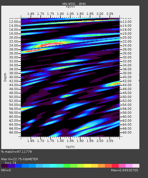
| Estimated Moho Depth: |
22.75 km |
| Estimated Crust Vp/Vs: |
1.74 |
| Assumed Crust Vp: |
4.05 km/s |
| Estimated Crust Vs: |
2.328 km/s |
| Estimated Crust Poisson's Ratio: |
0.25 |
|
| Radial Match: |
97.11779 % |
| Radial Bump: |
400 |
| Transverse Match: |
95.87892 % |
| Transverse Bump: |
400 |
| SOD ConfigId: |
2504 |
| Insert Time: |
2010-03-08 18:03:02.753 +0000 |
| GWidth: |
2.5 |
| Max Bumps: |
400 |
| Tol: |
0.001 |
|

Signal To Noise
| Channel | StoN | STA | LTA |
| MN:WDD: :BHN:20080705T02:22:57.203022Z | 42.49351 | 1.8115237E-5 | 4.2630595E-7 |
| MN:WDD: :BHE:20080705T02:22:57.203022Z | 13.958456 | 3.7427906E-6 | 2.6813785E-7 |
| MN:WDD: :BHZ:20080705T02:22:57.203022Z | 9.862516 | 2.3805649E-6 | 2.41375E-7 |
| Arrivals |
| Ps | 4.2 SECOND |
| PpPs | 15 SECOND |
| PsPs/PpSs | 19 SECOND |


