You are here: Home > Network List > MN - MEDNET Project Stations List
> Station WDD Wield Dalam, Malta > Earthquake Result Viewer
WDD Wield Dalam, Malta - Earthquake Result Viewer
| Earthquake location: |
Colombia |
| Earthquake latitude/longitude: |
5.1/-75.7 |
| Earthquake time(UTC): |
1995/08/19 (231) 21:43:32 GMT |
| Earthquake Depth: |
125 km |
| Earthquake Magnitude: |
6.1 MB, 6.6 UNKNOWN, 6.5 MW |
| Earthquake Catalog/Contributor: |
WHDF/NEIC |
|
| Network: |
MN MEDNET Project |
| Station: |
WDD Wield Dalam, Malta |
| Lat/Lon: |
35.87 N/14.52 E |
| Elevation: |
41 m |
|
| Distance: |
87.2 deg |
| Az: |
54.409 deg |
| Baz: |
274.239 deg |
| Ray Param: |
0.043214075 |
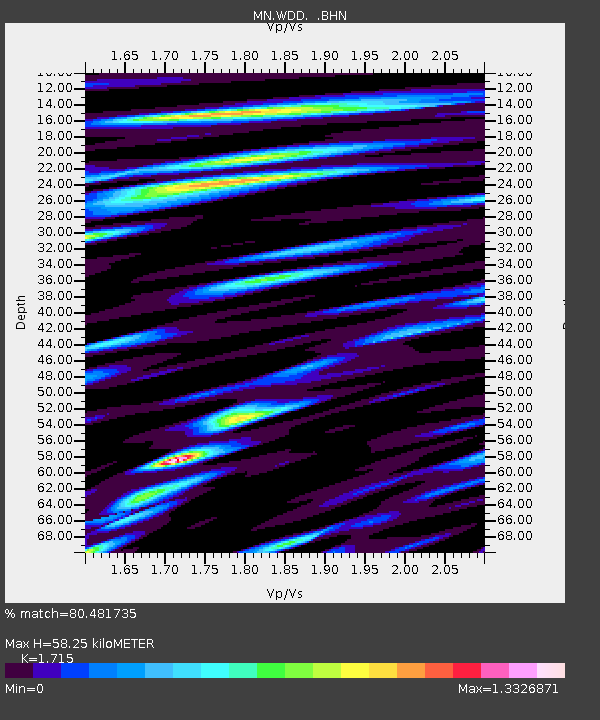
| Estimated Moho Depth: |
58.25 km |
| Estimated Crust Vp/Vs: |
1.72 |
| Assumed Crust Vp: |
4.05 km/s |
| Estimated Crust Vs: |
2.362 km/s |
| Estimated Crust Poisson's Ratio: |
0.24 |
|
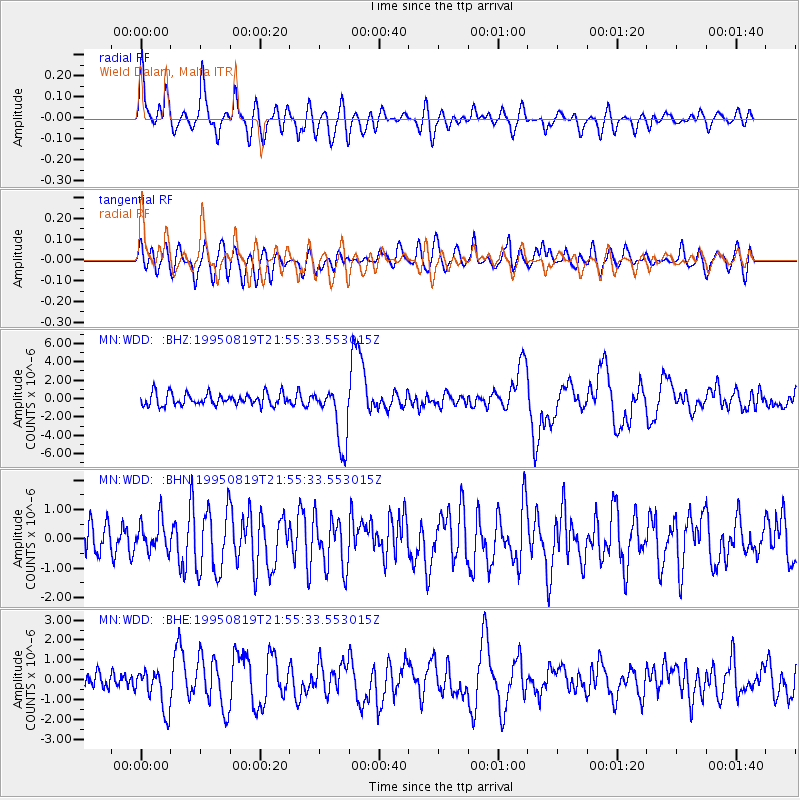
| Radial Match: |
80.481735 % |
| Radial Bump: |
400 |
| Transverse Match: |
66.42394 % |
| Transverse Bump: |
400 |
| SOD ConfigId: |
6273 |
| Insert Time: |
2010-03-08 18:03:22.280 +0000 |
| GWidth: |
2.5 |
| Max Bumps: |
400 |
| Tol: |
0.001 |
|
Signal To Noise
| Channel | StoN | STA | LTA |
| MN:WDD: :BHN:19950819T21:55:33.553015Z | 1.1064287 | 5.2041975E-7 | 4.7035994E-7 |
| MN:WDD: :BHE:19950819T21:55:33.553015Z | 1.9314989 | 1.0174247E-6 | 5.267539E-7 |
| MN:WDD: :BHZ:19950819T21:55:33.553015Z | 4.8746977 | 3.214801E-6 | 6.594873E-7 |
| Arrivals |
| Ps | 10 SECOND |
| PpPs | 39 SECOND |
| PsPs/PpSs | 49 SECOND |


