WDD Wield Dalam, Malta - Earthquake Result Viewer
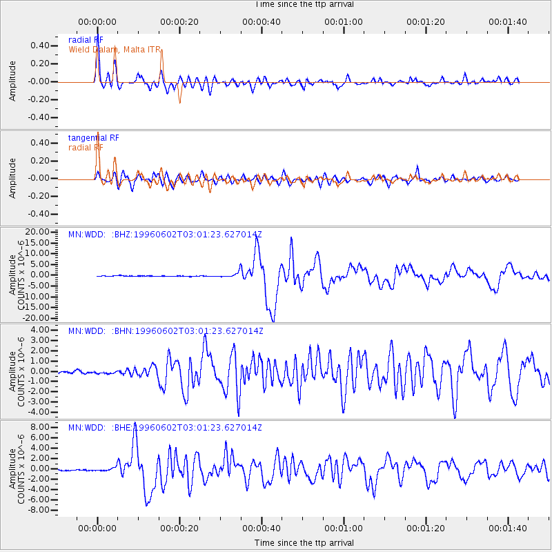
Earthquake location: Northern Mid-Atlantic Ridge
Earthquake latitude/longitude: 10.8/-42.3
Earthquake time(UTC): 1996/06/02 (154) 02:52:09 GMT
Earthquake Depth: 10 km
Earthquake Magnitude: 6.1 MB, 6.9 MS, 7.0 UNKNOWN, 6.8 MW
Earthquake Catalog/Contributor: WHDF/NEIC
Network: MN MEDNET Project
Station: WDD Wield Dalam, Malta
Lat/Lon: 35.87 N/14.52 E
Elevation: 41 m
Distance: 56.9 deg
Az: 54.186 deg
Baz: 258.794 deg
Ray Param: 0.063826345
Estimated Moho Depth: 19.75 km
Estimated Crust Vp/Vs: 1.87
Assumed Crust Vp: 4.05 km/s
Estimated Crust Vs: 2.169 km/s
Estimated Crust Poisson's Ratio: 0.30
Radial Match: 91.457146 %
Radial Bump: 400
Transverse Match: 87.87927 %
Transverse Bump: 400
SOD ConfigId: 6273
Insert Time: 2010-03-08 18:03:27.961 +0000
GWidth: 2.5
Max Bumps: 400
Tol: 0.001

Signal To Noise

ChannelStoNSTALTA
MN:WDD: :BHN:19960602T03:01:23.627014Z1.00475441.01420945E-71.0094102E-7
MN:WDD: :BHE:19960602T03:01:23.627014Z3.7091513.9391347E-71.0620044E-7
MN:WDD: :BHZ:19960602T03:01:23.627014Z9.9491541.233459E-61.2397628E-7
Arrivals
Ps4.3 SECOND
PpPs14 SECOND
PsPs/PpSs18 SECOND