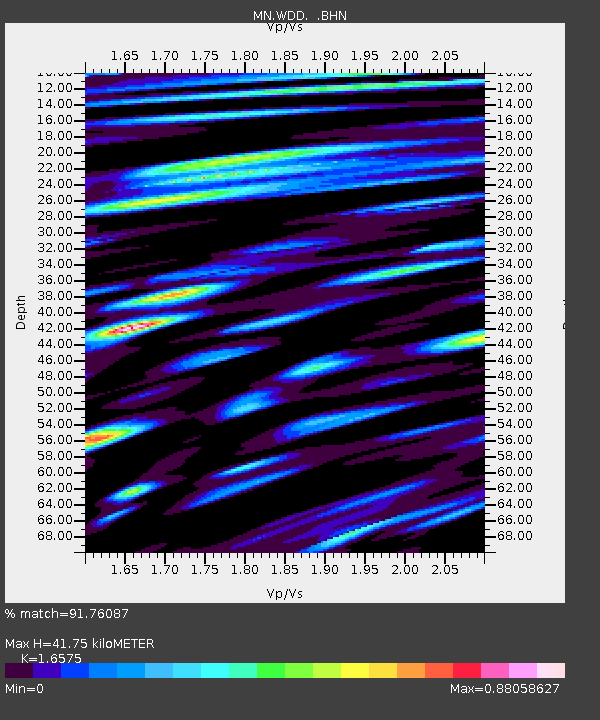
WDD Wield Dalam, Malta - Earthquake Result Viewer
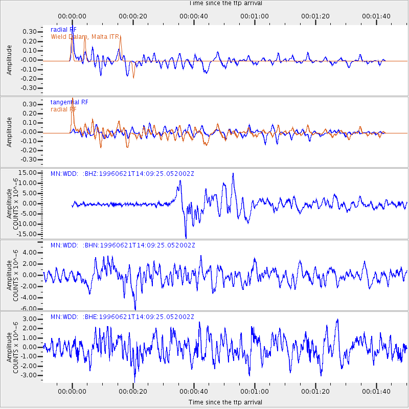
Earthquake location: Off East Coast Of Kamchatka
Earthquake latitude/longitude: 51.6/159.1
Earthquake time(UTC): 1996/06/21 (173) 13:57:10 GMT
Earthquake Depth: 20 km
Earthquake Magnitude: 6.0 MB, 6.6 MS, 7.0 UNKNOWN, 6.5 MS
Earthquake Catalog/Contributor: WHDF/NEIC
Network: MN MEDNET Project
Station: WDD Wield Dalam, Malta
Lat/Lon: 35.87 N/14.52 E
Elevation: 41 m
Distance: 87.6 deg
Az: 331.901 deg
Baz: 21.218 deg
Ray Param: 0.04322041
Estimated Moho Depth: 41.75 km
Estimated Crust Vp/Vs: 1.66
Assumed Crust Vp: 4.05 km/s
Estimated Crust Vs: 2.444 km/s
Estimated Crust Poisson's Ratio: 0.21
Radial Match: 91.76087 %
Radial Bump: 400
Transverse Match: 81.91491 %
Transverse Bump: 400
SOD ConfigId: 6273
Insert Time: 2010-03-08 18:03:30.861 +0000
GWidth: 2.5
Max Bumps: 400
Tol: 0.001

Signal To Noise

ChannelStoNSTALTA
MN:WDD: :BHN:19960621T14:09:25.052002Z1.53552017.4579583E-74.856959E-7
MN:WDD: :BHE:19960621T14:09:25.052002Z1.64015667.328351E-74.4680797E-7
MN:WDD: :BHZ:19960621T14:09:25.052002Z6.47718522.6811783E-64.1394188E-7
Arrivals
Ps6.8 SECOND
PpPs27 SECOND
PsPs/PpSs34 SECOND