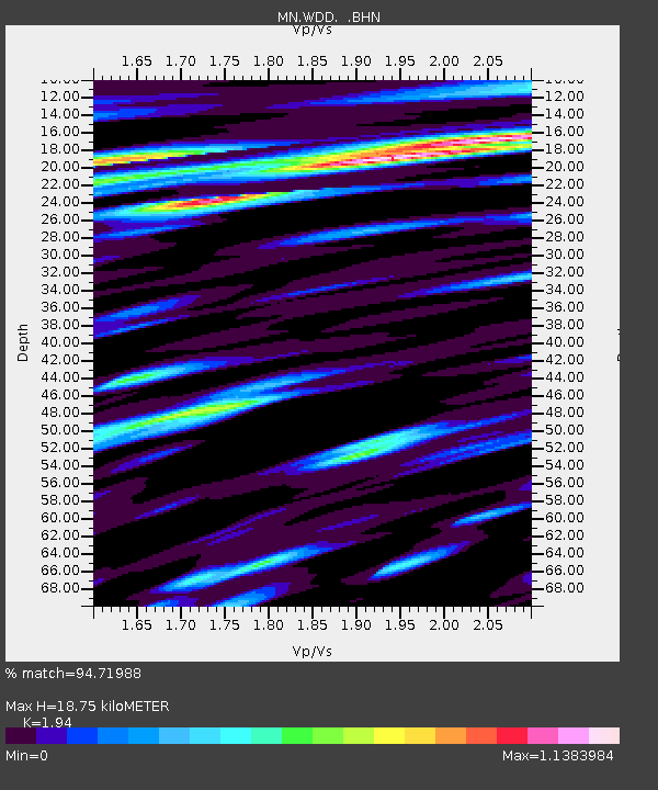
WDD Wield Dalam, Malta - Earthquake Result Viewer
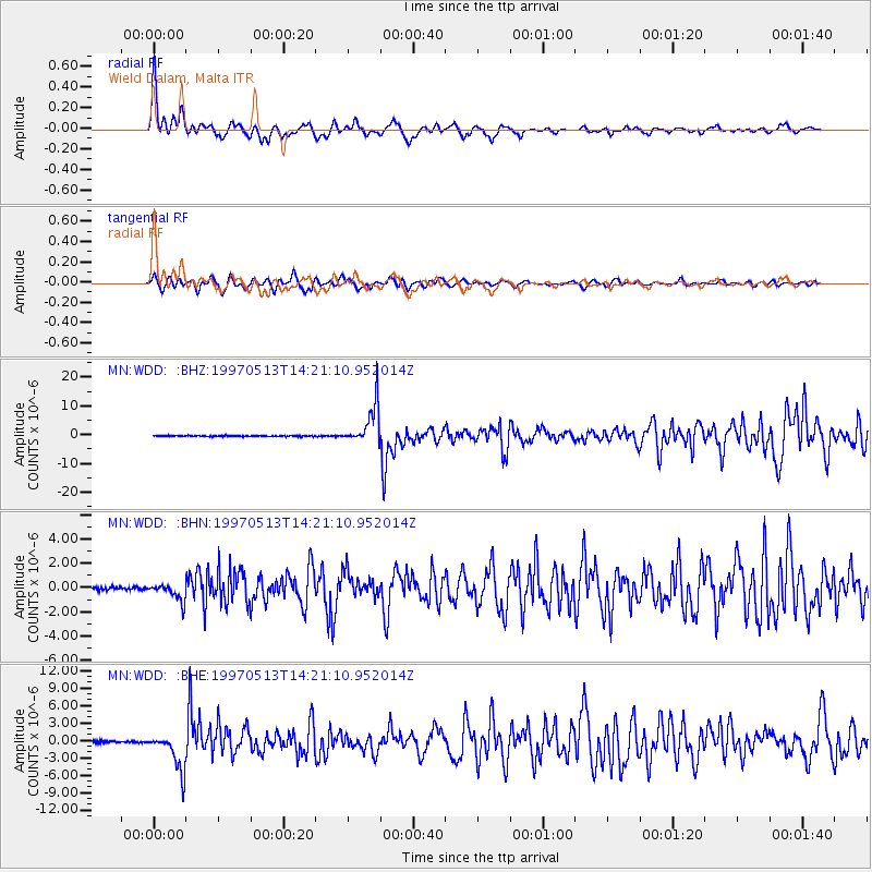
Earthquake location: Hindu Kush Region, Afghanistan
Earthquake latitude/longitude: 36.4/70.9
Earthquake time(UTC): 1997/05/13 (133) 14:13:45 GMT
Earthquake Depth: 196 km
Earthquake Magnitude: 6.1 MB, 6.5 UNKNOWN, 6.4 MW
Earthquake Catalog/Contributor: WHDF/NEIC
Network: MN MEDNET Project
Station: WDD Wield Dalam, Malta
Lat/Lon: 35.87 N/14.52 E
Elevation: 41 m
Distance: 45.0 deg
Az: 286.858 deg
Baz: 71.891 deg
Ray Param: 0.0708092
Estimated Moho Depth: 18.75 km
Estimated Crust Vp/Vs: 1.94
Assumed Crust Vp: 4.05 km/s
Estimated Crust Vs: 2.088 km/s
Estimated Crust Poisson's Ratio: 0.32
Radial Match: 94.71988 %
Radial Bump: 353
Transverse Match: 89.16323 %
Transverse Bump: 400
SOD ConfigId: 6273
Insert Time: 2010-03-08 18:03:34.787 +0000
GWidth: 2.5
Max Bumps: 400
Tol: 0.001

Signal To Noise

ChannelStoNSTALTA
MN:WDD: :BHN:19970513T14:21:10.952014Z6.07921937.2157343E-71.18695084E-7
MN:WDD: :BHE:19970513T14:21:10.952014Z21.554573.1831134E-61.4767697E-7
MN:WDD: :BHZ:19970513T14:21:10.952014Z39.0155036.8455947E-61.7545833E-7
Arrivals
Ps4.4 SECOND
PpPs13 SECOND
PsPs/PpSs18 SECOND