You are here: Home > Network List > MN - MEDNET Project Stations List
> Station WDD Wield Dalam, Malta > Earthquake Result Viewer
WDD Wield Dalam, Malta - Earthquake Result Viewer
| Earthquake location: |
Near Coast Of Venezuela |
| Earthquake latitude/longitude: |
10.6/-63.5 |
| Earthquake time(UTC): |
1997/07/09 (190) 19:24:13 GMT |
| Earthquake Depth: |
20 km |
| Earthquake Magnitude: |
6.2 MB, 6.8 MS, 7.0 UNKNOWN, 6.6 ME |
| Earthquake Catalog/Contributor: |
WHDF/NEIC |
|
| Network: |
MN MEDNET Project |
| Station: |
WDD Wield Dalam, Malta |
| Lat/Lon: |
35.87 N/14.52 E |
| Elevation: |
41 m |
|
| Distance: |
74.2 deg |
| Az: |
55.667 deg |
| Baz: |
271.743 deg |
| Ray Param: |
0.05248278 |
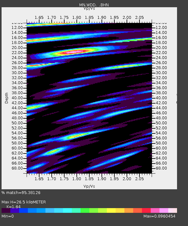
| Estimated Moho Depth: |
26.5 km |
| Estimated Crust Vp/Vs: |
1.64 |
| Assumed Crust Vp: |
4.05 km/s |
| Estimated Crust Vs: |
2.47 km/s |
| Estimated Crust Poisson's Ratio: |
0.20 |
|
| Radial Match: |
95.38126 % |
| Radial Bump: |
400 |
| Transverse Match: |
89.83657 % |
| Transverse Bump: |
400 |
| SOD ConfigId: |
6273 |
| Insert Time: |
2010-03-08 18:03:36.288 +0000 |
| GWidth: |
2.5 |
| Max Bumps: |
400 |
| Tol: |
0.001 |
|
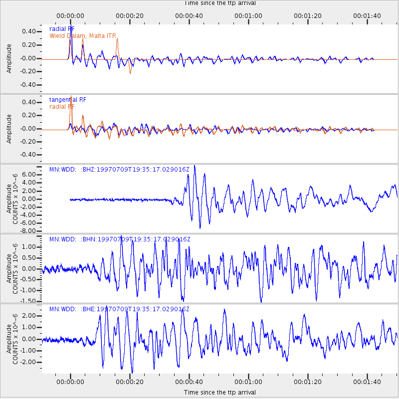
Signal To Noise
| Channel | StoN | STA | LTA |
| MN:WDD: :BHN:19970709T19:35:17.029016Z | 0.9288221 | 8.474715E-8 | 9.124153E-8 |
| MN:WDD: :BHE:19970709T19:35:17.029016Z | 1.6647816 | 1.7175427E-7 | 1.0316925E-7 |
| MN:WDD: :BHZ:19970709T19:35:17.029016Z | 3.3176055 | 3.7553514E-7 | 1.1319463E-7 |
| Arrivals |
| Ps | 4.2 SECOND |
| PpPs | 17 SECOND |
| PsPs/PpSs | 21 SECOND |


