You are here: Home > Network List > MN - MEDNET Project Stations List
> Station WDD Wield Dalam, Malta > Earthquake Result Viewer
WDD Wield Dalam, Malta - Earthquake Result Viewer
| Earthquake location: |
Northern Peru |
| Earthquake latitude/longitude: |
-4.4/-76.7 |
| Earthquake time(UTC): |
1997/10/28 (301) 06:15:17 GMT |
| Earthquake Depth: |
112 km |
| Earthquake Magnitude: |
6.6 MB, 6.3 MS, 7.2 UNKNOWN, 6.6 ME |
| Earthquake Catalog/Contributor: |
WHDF/NEIC |
|
| Network: |
MN MEDNET Project |
| Station: |
WDD Wield Dalam, Malta |
| Lat/Lon: |
35.87 N/14.52 E |
| Elevation: |
41 m |
|
| Distance: |
93.5 deg |
| Az: |
54.448 deg |
| Baz: |
267.173 deg |
| Ray Param: |
0.04118615 |
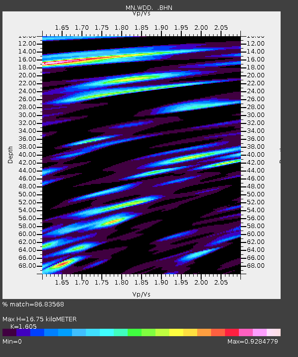
| Estimated Moho Depth: |
16.75 km |
| Estimated Crust Vp/Vs: |
1.61 |
| Assumed Crust Vp: |
4.05 km/s |
| Estimated Crust Vs: |
2.524 km/s |
| Estimated Crust Poisson's Ratio: |
0.18 |
|
| Radial Match: |
86.83568 % |
| Radial Bump: |
400 |
| Transverse Match: |
84.04298 % |
| Transverse Bump: |
400 |
| SOD ConfigId: |
6273 |
| Insert Time: |
2010-03-08 18:03:39.686 +0000 |
| GWidth: |
2.5 |
| Max Bumps: |
400 |
| Tol: |
0.001 |
|
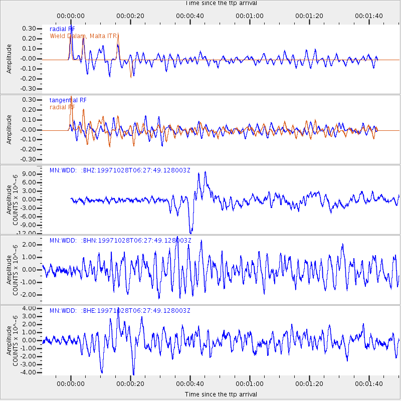
Signal To Noise
| Channel | StoN | STA | LTA |
| MN:WDD: :BHN:19971028T06:27:49.128003Z | 0.71454144 | 3.7876254E-7 | 5.300777E-7 |
| MN:WDD: :BHE:19971028T06:27:49.128003Z | 1.456921 | 6.245573E-7 | 4.2868302E-7 |
| MN:WDD: :BHZ:19971028T06:27:49.128003Z | 3.0239947 | 1.3974745E-6 | 4.6212864E-7 |
| Arrivals |
| Ps | 2.5 SECOND |
| PpPs | 11 SECOND |
| PsPs/PpSs | 13 SECOND |


