You are here: Home > Network List > MN - MEDNET Project Stations List
> Station WDD Wield Dalam, Malta > Earthquake Result Viewer
WDD Wield Dalam, Malta - Earthquake Result Viewer
| Earthquake location: |
North Atlantic Ocean |
| Earthquake latitude/longitude: |
52.7/-33.7 |
| Earthquake time(UTC): |
1998/02/16 (047) 23:53:19 GMT |
| Earthquake Depth: |
10 km |
| Earthquake Magnitude: |
6.1 MB, 6.6 MS, 6.8 UNKNOWN, 6.8 ME |
| Earthquake Catalog/Contributor: |
WHDF/NEIC |
|
| Network: |
MN MEDNET Project |
| Station: |
WDD Wield Dalam, Malta |
| Lat/Lon: |
35.87 N/14.52 E |
| Elevation: |
41 m |
|
| Distance: |
37.6 deg |
| Az: |
97.047 deg |
| Baz: |
311.989 deg |
| Ray Param: |
0.07604878 |
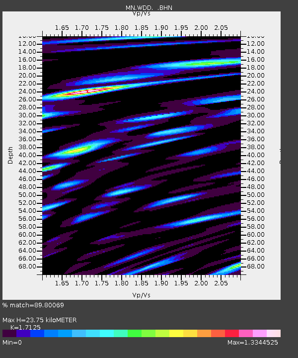
| Estimated Moho Depth: |
23.75 km |
| Estimated Crust Vp/Vs: |
1.71 |
| Assumed Crust Vp: |
4.05 km/s |
| Estimated Crust Vs: |
2.365 km/s |
| Estimated Crust Poisson's Ratio: |
0.24 |
|
| Radial Match: |
89.80069 % |
| Radial Bump: |
400 |
| Transverse Match: |
72.678665 % |
| Transverse Bump: |
400 |
| SOD ConfigId: |
6273 |
| Insert Time: |
2010-03-08 18:03:41.065 +0000 |
| GWidth: |
2.5 |
| Max Bumps: |
400 |
| Tol: |
0.001 |
|
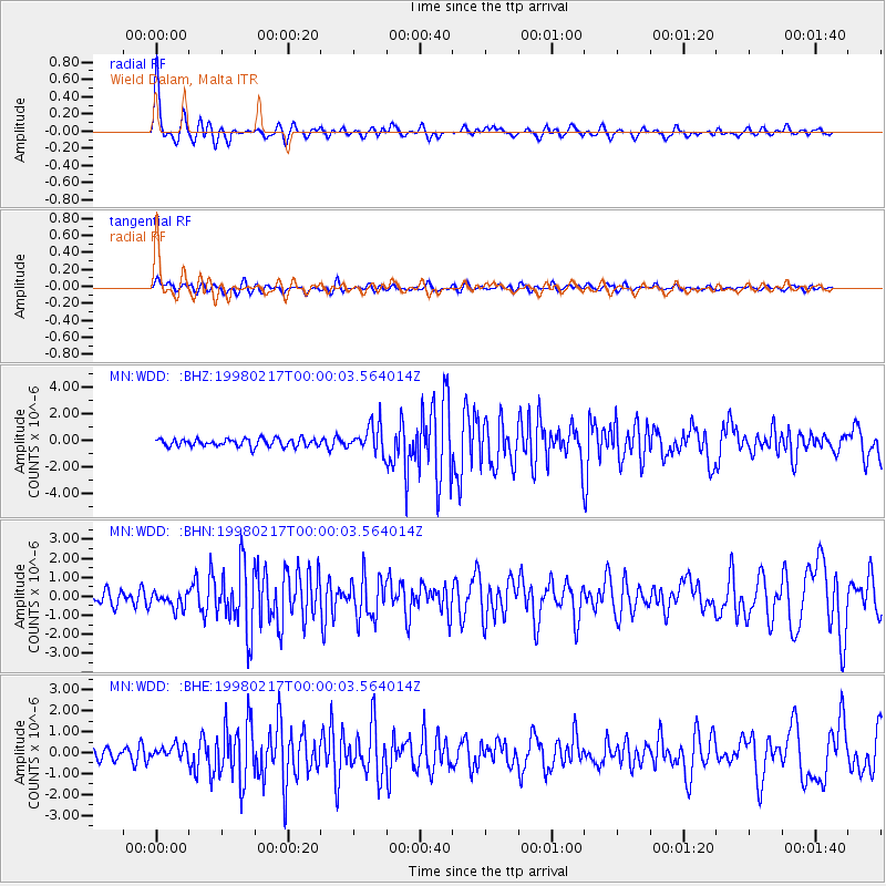
Signal To Noise
| Channel | StoN | STA | LTA |
| MN:WDD: :BHN:19980217T00:00:03.564014Z | 1.3772007 | 4.2838403E-7 | 3.1105418E-7 |
| MN:WDD: :BHE:19980217T00:00:03.564014Z | 1.3069377 | 3.2381948E-7 | 2.4776963E-7 |
| MN:WDD: :BHZ:19980217T00:00:03.564014Z | 3.599514 | 1.0565931E-6 | 2.935377E-7 |
| Arrivals |
| Ps | 4.3 SECOND |
| PpPs | 15 SECOND |
| PsPs/PpSs | 20 SECOND |


